Íomhá:Danubemap.jpg
Size of this preview: 800 × 577 picteilín. Other resolutions: 320 × 231 picteilín | 640 × 462 picteilín | 998 × 720 picteilín.
Taispeáin leagan ardtaifigh den íomhá (998 × 720 picteilín, méid comhaid: 389 KB, cineál MIME: image/jpeg)
| Seo comhad as An Cómhaoin Viciméid. Tá an tuairisc as an leathanach tuairisc Cómhaoin a leanas thíos.
|
Achoimriú
| Tuairisc |
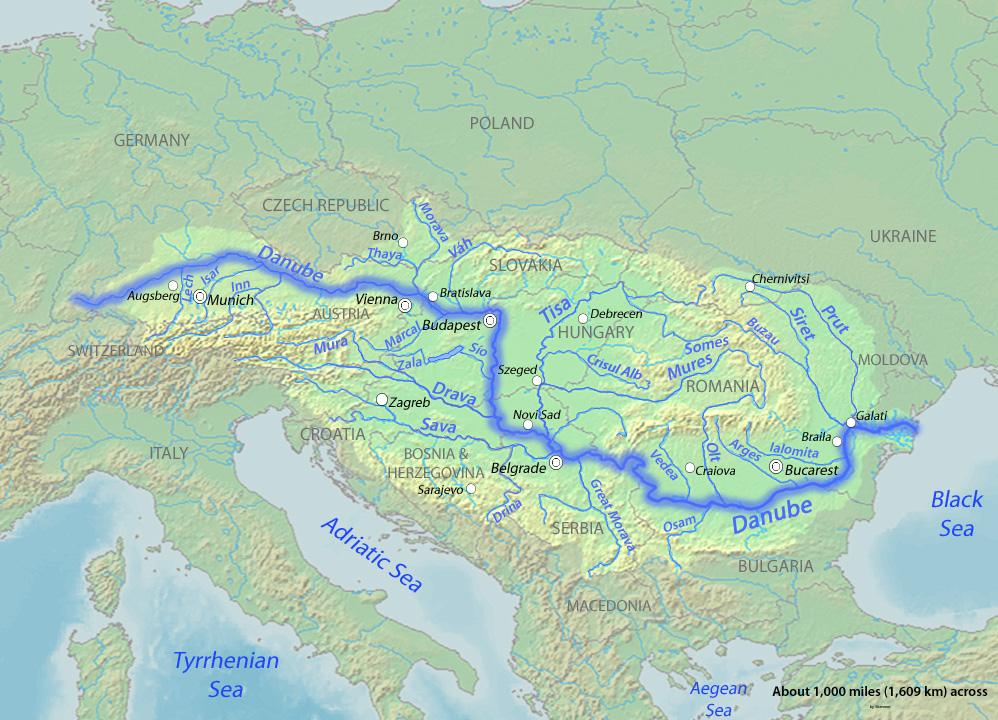
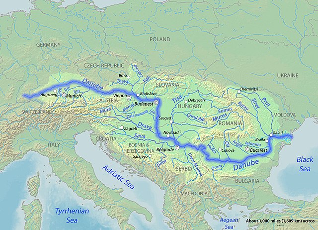
English: Map of the Danube,hhhhhhhhhhhhhhhhghfrxygtjhcvkblgvhfygtyfrtzvh largest river of Central Europe. Created to fill a gap in which all the other Danube maps do not fulfill. fhfjhfjhjvhfwjhvwhmjvxmjhwqvdsjydw1h2cfvjg |
| Dáta | to 23 |
| Foinse | Background and river course data from http://www2.demis.nl/mapserver/mapper.asp |
| Údar | Shannon |
Ceadúnú
Is mise sealbhóir cóipchirt an shaothair seo agus foilsím é faoi na ceadúnais seo a leanas:

|
Tugtar cead an doiciméad seo a chóipeáil, a dháileadh agus/nó a mhodhnú faoi théarmaí an Ceadúnas Doiciméadúcháin Saor ó GNU, Leagan 1.2 nó aon leagan níos déanaí a d’fhoilsigh an Fondúireacht Bogearraí Saor in Aisce; gan aon Rannóga Inmheánacha, gan aon Téacsanna Clúdaigh Tosaigh, agus gan aon Téacsanna Clúdaigh Cúil. Tá cóip den cheadúnas san áireamh sa chuid dar teideal Ceadúnas Doiciméadúcháin Saor ó GNU. |
This file is licensed under the Creative Commons Attribution-Share Alike 4.0 International, 3.0 Unported, 2.5 Generic, 2.0 Generic and 1.0 Generic license.
- Is féidir:
- an saothar seo a roinnt – an saothar seo a chóipeáil, a dháil amach, agus a tharchur
- an saothar seo a athmheascadh – an saothar seo a oiriúnú
- Ach amháin má leantar na coinníollacha seo a leanas:
- sannadh – Ní mor creidiúint a thabhairt leis an saothar, faoi mar a shonraigh an údar nó tabharthóir an ceadúnais (ach ná húsáid modh a thugann le fios go thacaíonn sé/sí tú féin nó an úsáid a bhaineann tú as an saothar).
- comhroinn araon – Má athraíonn tú nó síneann tú amach an saothar seo, ní féidir é a dháileadh ach amhaín faoin gceadúnas céanna nó ceann cosúil leis an gceann seo.
Is féidir leat a roghnú an ceadúnas do rogha
Stair chomhaid
Cliceáil ar dáta/am chun an comhad a radharc mar a bhí sé ag an am sin.
| Dáta/Am | Mionsamhail | Toisí | Úsáideoir | Nóta tráchta | |
|---|---|---|---|---|---|
| faoi láthair | 05:13, 24 Márta 2010 | | 998 × 720 (389 KB) | Shannon1 | {{Information |Description={{en|1=Map of the Danube, the largest river of Central Europe. Created to fill a gap in which all the other Danube maps do not fulfill.}} |Source=Background and river course data from http://www2.demis.nl/mapserver/mapper.as |
Úsáid comhaid
Níl nasc ó aon leathanach eile don íomhá seo.
Global file usage
The following other wikis use this file:
- Úsáid ar ast.wiktionary.org
- Úsáid ar el.wikipedia.org
- Úsáid ar en.wikipedia.org
- Úsáid ar es.wikipedia.org
- Úsáid ar et.wikipedia.org
- Úsáid ar ka.wikipedia.org
- Úsáid ar lt.wikipedia.org
- Úsáid ar mk.wikipedia.org
- Úsáid ar os.wikipedia.org
- Úsáid ar sl.wikipedia.org
- Úsáid ar zh.wikipedia.org
View more global usage of this file.