Íomhá:Desert greenery ESA19443666.jpeg

Taispeáin leagan ardtaifigh den íomhá (20,982 × 30,978 picteilín, méid comhaid: 22.91 MB, cineál MIME: image/jpeg)
| Seo comhad as An Cómhaoin Viciméid. Tá an tuairisc as an leathanach tuairisc Cómhaoin a leanas thíos.
|
Achoimriú
| Warning | The original file is very high-resolution. It might not load properly or could cause your browser to freeze when opened at full size. |
|---|
| Tuairisc |
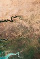
English: Today marks the 25th anniversary of World Day to Combat Desertification and Drought (WDCD). Under its theme ‘Let’s grow the future together,’ the initiative celebrates the 25 years of progress made in sustainable land management. One ambitious project – the Great Green Wall – aims to improve life in Africa’s desert regions by planting a belt of trees across the entire width of the continent. Once completed, the wall will be the largest living structure on the planet stretching across 20 countries - from Senegal in the west to Djibouti in the east. By 2030, the initiative aims to have restored 100 million hectares of degraded land, sequestered 250 million tonnes of carbon and created 10 million green jobs. Captured by the Copernicus Sentinel-2 mission, this image shows the edge of the dry desert in west Africa contrasted with vegetated land. Signs of land degradation can be seen as brighter “islands” around villages and to a lesser extent along roads and rivers showing bare soil and degraded vegetation. The image shows parts of three African countries: Senegal, The Gambia and Guinea-Bissau. See the image at its full resolution to zoom in on the area. Since the Green Wall started in 2007, progress has been made in restoring the Sahelian lands. In Senegal alone, almost 12 million trees have been planted, and 25 000 hectares of degraded land restored. Desertification is the degradation of dry land ecosystems, owing to overexploitation through human activities and climate change. According to the UN, 12 million hectares of land is lost yearly because of desertification and drought, and 75 billion tonnes of fertile soil is lost due to land degradation. Copernicus Sentinel-2 is a two-satellite mission. Each satellite carries a high-resolution camera that images Earth’s surface in 13 spectral bands. The mission is mostly used to track changes in the way land is being used and to monitor the health of vegetation. |
| Dáta | 17 Meitheamh 2019 (upload date) |
| Foinse | Desert greenery |
| Údar | European Space Agency |
| Leaganacha eile |
|
| Activity | Observing the Earth |
| Mission | Sentinel-2 |
| System | Copernicus |
Ceadúnú

|
This image contains data from a satellite in the Copernicus Programme, such as Sentinel-1, Sentinel-2 or Sentinel-3. Attribution is required when using this image.
Creidiúint: Contains modified Copernicus Sentinel data 2019
The use of Copernicus Sentinel Data is regulated under EU law (Commission Delegated Regulation (EU) No 1159/2013 and Regulation (EU) No 377/2014). Relevant excerpts:
Free access shall be given to GMES dedicated data [...] made available through GMES dissemination platforms [...].
Access to GMES dedicated data [...] shall be given for the purpose of the following use in so far as it is lawful:
GMES dedicated data [...] may be used worldwide without limitations in time.
GMES dedicated data and GMES service information are provided to users without any express or implied warranty, including as regards quality and suitability for any purpose. |
This media was created by the European Space Agency (ESA).
Where expressly so stated, images or videos are covered by the Creative Commons Attribution-ShareAlike 3.0 IGO (CC BY-SA 3.0 IGO) licence, ESA being an Intergovernmental Organisation (IGO), as defined by the CC BY-SA 3.0 IGO licence. The user is allowed under the terms and conditions of the CC BY-SA 3.0 IGO license to Reproduce, Distribute and Publicly Perform the ESA images and videos released under CC BY-SA 3.0 IGO licence and the Adaptations thereof, without further explicit permission being necessary, for as long as the user complies with the conditions and restrictions set forth in the CC BY-SA 3.0 IGO licence, these including that:
See the ESA Creative Commons copyright notice for complete information, and this article for additional details.
|
 | |
This file is licensed under the Creative Commons Attribution-ShareAlike 3.0 IGO license. Creidiúint: ESA, CC BY-SA IGO 3.0
| ||
Stair chomhaid
Cliceáil ar dáta/am chun an comhad a radharc mar a bhí sé ag an am sin.
| Dáta/Am | Mionsamhail | Toisí | Úsáideoir | Nóta tráchta | |
|---|---|---|---|---|---|
| faoi láthair | 10:16, 10 Meitheamh 2020 | | 20,982 × 30,978 (22.91 MB) | OptimusPrimeBot | #Spacemedia - Upload of https://www.esa.int/var/esa/storage/images/esa_multimedia/images/2019/06/desert_greenery/19443656-1-eng-GB/Desert_greenery.jpg via Commons:Spacemedia |
Úsáid comhaid
Tá nasc chuig an gcomhad seo ar 2 an leathanach seo a leanas:
Global file usage
The following other wikis use this file:
- Úsáid ar en.wikipedia.org
- Úsáid ar nl.wikipedia.org