Íomhá:GoldenHorde1300.png

Size of this preview: 800 × 481 picteilín. Other resolutions: 320 × 193 picteilín | 640 × 385 picteilín | 1,024 × 616 picteilín | 1,436 × 864 picteilín.
Taispeáin leagan ardtaifigh den íomhá (1,436 × 864 picteilín, méid comhaid: 47 KB, cineál MIME: image/png)
| Seo comhad as An Cómhaoin Viciméid. Tá an tuairisc as an leathanach tuairisc Cómhaoin a leanas thíos.
|

|
This map image could be re-created using vector graphics as an SVG file. This has several advantages; see Commons:Media for cleanup for more information. If an SVG form of this image is available, please upload it and afterwards replace this template with
{{vector version available|new image name}}.
It is recommended to name the SVG file “GoldenHorde1300.svg”—then the template Vector version available (or Vva) does not need the new image name parameter. |
Achoimriú
| Tuairisc |
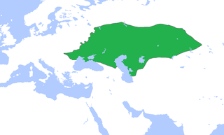
English: Locator map of the Golden Horde, c. 1300.
(Partially based on Atlas of World History (2007) - The World 1200-1300, map) |
| Dáta | |
| Foinse | Obair féin |
| Údar | Gabagool |
Ceadúnú
Is mise sealbhóir cóipchirt an shaothair seo agus foilsím é faoin gceadúnas seo a leanas:
This file is licensed under the Creative Commons Attribution 3.0 Unported license.
- Is féidir:
- an saothar seo a roinnt – an saothar seo a chóipeáil, a dháil amach, agus a tharchur
- an saothar seo a athmheascadh – an saothar seo a oiriúnú
- Ach amháin má leantar na coinníollacha seo a leanas:
- sannadh – Ní mor creidiúint a thabhairt leis an saothar, faoi mar a shonraigh an údar nó tabharthóir an ceadúnais (ach ná húsáid modh a thugann le fios go thacaíonn sé/sí tú féin nó an úsáid a bhaineann tú as an saothar).
Stair chomhaid
Cliceáil ar dáta/am chun an comhad a radharc mar a bhí sé ag an am sin.
| Dáta/Am | Mionsamhail | Toisí | Úsáideoir | Nóta tráchta | |
|---|---|---|---|---|---|
| faoi láthair | 15:58, 16 Samhain 2022 | | 1,436 × 864 (47 KB) | Gyalu22 | Reverted to version as of 16:08, 5 June 2009 (UTC) |
| 16:12, 7 Meitheamh 2021 |  | 1,436 × 864 (28 KB) | Devlet Geray | Reverted to version as of 11:20, 4 June 2018 (UTC) they paid tribute to the Khan and because of this could trade but there were no independent states in Southern Crimea | |
| 12:04, 4 Meitheamh 2018 |  | 1,436 × 864 (28 KB) | Julieta39 | No Golden Horde control on the Southern Crimea (byzantine, later Theodoro principality) | |
| 11:20, 4 Meitheamh 2018 |  | 1,436 × 864 (28 KB) | Julieta39 | Shorelines, no modern dam lakes, Hungary and Galicia no ruled by Golden Horde | |
| 16:08, 5 Meitheamh 2009 |  | 1,436 × 864 (47 KB) | Gabagool | slightly cropped | |
| 13:00, 25 Aibreán 2009 |  | 1,644 × 959 (56 KB) | Gabagool | {{Information |Description={{en|1=Locator map of the Golden Horde, c. 1300. (Partially based on ''Atlas of World History'' (2007) - The World 1200-1300, map)}} |Source=Own work by uploader |Author=Gabagool / Jarle Grøhn |Date=2009-04-2 |
Úsáid comhaid
Tá nasc chuig an gcomhad seo ar na leathanaigh seo a leanas:
Global file usage
The following other wikis use this file:
- Úsáid ar af.wikipedia.org
- Úsáid ar ar.wikipedia.org
- Úsáid ar arz.wikipedia.org
- Úsáid ar ast.wikipedia.org
- Úsáid ar azb.wikipedia.org
- Úsáid ar az.wikipedia.org
- Úsáid ar be.wikipedia.org
- Úsáid ar bs.wikipedia.org
- Úsáid ar ca.wikipedia.org
- Úsáid ar cs.wikipedia.org
- Úsáid ar cv.wikipedia.org
- Úsáid ar cy.wikipedia.org
- Úsáid ar da.wikipedia.org
- Úsáid ar el.wikipedia.org
- Úsáid ar en.wikipedia.org
- Úsáid ar eo.wikipedia.org
- Úsáid ar es.wikipedia.org
- Úsáid ar et.wikipedia.org
- Úsáid ar eu.wikipedia.org
- Úsáid ar fa.wikipedia.org
- Úsáid ar fr.wikipedia.org
- Úsáid ar gl.wikipedia.org
- Úsáid ar hi.wikipedia.org
- Úsáid ar hr.wikipedia.org
- Úsáid ar hu.wikipedia.org
- Úsáid ar hy.wikipedia.org
- Úsáid ar id.wikipedia.org
- Úsáid ar incubator.wikimedia.org
- Úsáid ar it.wikipedia.org
View more global usage of this file.