Íomhá:Kosovo map-en.svg

Size of this PNG preview of this SVG file: 582 × 599 picteilín. Other resolutions: 233 × 240 picteilín | 466 × 480 picteilín | 746 × 768 picteilín | 994 × 1,024 picteilín | 1,989 × 2,048 picteilín | 1,777 × 1,830 picteilín.
Taispeáin leagan ardtaifigh den íomhá (Comhad SVG, ainmniúil 1,777 × 1,830 picteilíni, méid comhaid: 3.81 MB)
| Seo comhad as An Cómhaoin Viciméid. Tá an tuairisc as an leathanach tuairisc Cómhaoin a leanas thíos.
|
Achoimriú
| Cur síos |
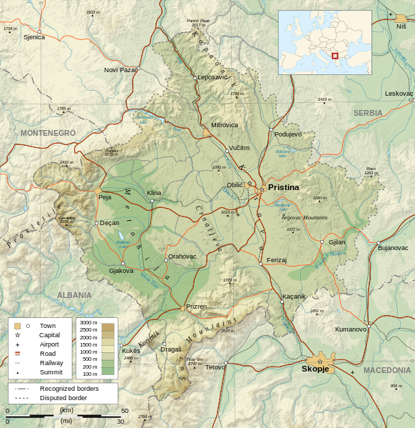
Čeština: Mapa Kosova. Dansk: Kort over Kosovo. Deutsch: Karte des Kosovo. English: Map of the Kosovo. Español: Mapa de Kosovo. Français : Carte du Kosovo, en anglais. Italiano: Mappa del Kosovo. Magyar: Koszovó térképe albán és szerb helységnevekkel. Polski: Mapa Kosowa. Română: Harta provinciei Kosovo Svenska: Karta över Kosovo, engelskspråkig. Türkçe: Kosova haritası. Македонски: Карта на Косово на англиски. Русский: Карта Косово, на английском. Українська: Карта Косово 日本語: コソボの地図。 |
||||||
| Dáta | |||||||
| Foinse |
Own work. Sources :
Software used :
Other data :
|
||||||
| Cruthaitheoir | |||||||
| Georeferencing | If inappropriate please set warp_status = skip to hide. | ||||||
| Leaganacha eile |
[] | ||||||
| Creidiúint (required by the license) | © Sémhur / Wikimedia Commons / | ||||||
| Assessments |
|
||||||
| SVG | W3C-validity not checked.
|
||||||
| Graphic Lab |


| Camera location | | View this and other nearby images on: OpenStreetMap |
|---|
Ceadúnú
Is mise sealbhóir cóipchirt an shaothair seo agus foilsím é faoi na ceadúnais seo a leanas:
| Copyleft: This work of art is free; you can redistribute it and/or modify it according to terms of the Free Art License. You will find a specimen of this license on the Copyleft Attitude site as well as on other sites. |
This file is licensed under the Creative Commons Attribution-Share Alike 4.0 International, 3.0 Unported, 2.5 Generic, 2.0 Generic and 1.0 Generic license.
- Is féidir:
- an saothar seo a roinnt – an saothar seo a chóipeáil, a dháil amach, agus a tharchur
- an saothar seo a athmheascadh – an saothar seo a oiriúnú
- Ach amháin má leantar na coinníollacha seo a leanas:
- sannadh – Ní mor creidiúint a thabhairt leis an saothar, faoi mar a shonraigh an údar nó tabharthóir an ceadúnais (ach ná húsáid modh a thugann le fios go thacaíonn sé/sí tú féin nó an úsáid a bhaineann tú as an saothar).
- comhroinn araon – Má athraíonn tú nó síneann tú amach an saothar seo, ní féidir é a dháileadh ach amhaín faoin gceadúnas céanna nó ceann cosúil leis an gceann seo.
Is féidir leat a roghnú an ceadúnas do rogha
Stair chomhaid
Cliceáil ar dáta/am chun an comhad a radharc mar a bhí sé ag an am sin.
| Dáta/Am | Mionsamhail | Toisí | Úsáideoir | Nóta tráchta | |
|---|---|---|---|---|---|
| faoi láthair | 14:35, 21 Meán Fómhair 2023 | | 1,777 × 1,830 (3.81 MB) | Socialdilema | File uploaded using svgtranslate tool (https://svgtranslate.toolforge.org/). Added translation for ca. |
| 18:41, 12 Bealtaine 2021 |  | 1,777 × 1,830 (3.74 MB) | Uniacademic | Same as the previous edit. | |
| 18:28, 12 Bealtaine 2021 |  | 1,777 × 1,830 (3.74 MB) | Uniacademic | Updated the names of cities in cases where WP:COMMONNAME has changed since 2008. | |
| 09:14, 5 Márta 2008 |  | 1,777 × 1,830 (3.75 MB) | Sémhur | Added borders, with keys (recognized - disputed) | |
| 09:16, 4 Márta 2008 |  | 1,777 × 1,830 (3.74 MB) | Sémhur | Remove Kosovo boundaries to neutralize the map, + labels more readable | |
| 14:45, 3 Márta 2008 |  | 1,777 × 1,830 (3.74 MB) | Sémhur | Correcting few labels | |
| 19:15, 28 Feabhra 2008 |  | 1,777 × 1,830 (3.74 MB) | Sémhur | minor changes | |
| 11:37, 26 Feabhra 2008 |  | 1,777 × 1,830 (3.74 MB) | Sémhur | == Description == {{Information |Description= {{en| Map of the Kosovo.}} {{fr| Carte du Kosovo, en anglais.}} |Source=Own work. {{clr}} Sources : * Topographic background : [http://www2.jpl.nasa.gov/srtm NASA Shuttle Radar To |
Úsáid comhaid
Tá nasc chuig an gcomhad seo ar na leathanaigh seo a leanas:
Global file usage
The following other wikis use this file:
- Úsáid ar af.wikipedia.org
- Úsáid ar ar.wikipedia.org
- Úsáid ar az.wikipedia.org
- Úsáid ar bcl.wikipedia.org
- Úsáid ar be-tarask.wikipedia.org
- Úsáid ar bg.wikipedia.org
- Úsáid ar de.wikipedia.org
- Úsáid ar de.wikibooks.org
- Úsáid ar en.wikipedia.org
- Úsáid ar es.wikipedia.org
- Úsáid ar fa.wikipedia.org
- Úsáid ar fi.wikipedia.org
- Úsáid ar fr.wikipedia.org
- Úsáid ar fr.wikinews.org
- Úsáid ar gl.wikipedia.org
- Úsáid ar gv.wikipedia.org
- Úsáid ar hy.wikipedia.org
- Úsáid ar is.wikipedia.org
- Úsáid ar ko.wikipedia.org
- Úsáid ar lt.wikipedia.org
- Úsáid ar mg.wikipedia.org
- Úsáid ar ml.wikipedia.org
- Úsáid ar mr.wikipedia.org
- Úsáid ar mzn.wikipedia.org
- Úsáid ar nn.wikipedia.org
- Úsáid ar no.wikipedia.org
- Úsáid ar pa.wikipedia.org
View more global usage of this file.