Íomhá:MachiasBay1776.png
Size of this preview: 478 × 600 picteilín. Other resolutions: 191 × 240 picteilín | 600 × 753 picteilín.
Taispeáin leagan ardtaifigh den íomhá (600 × 753 picteilín, méid comhaid: 633 KB, cineál MIME: image/png)
| Seo comhad as An Cómhaoin Viciméid. Tá an tuairisc as an leathanach tuairisc Cómhaoin a leanas thíos.
|
Achoimriú
| Tuairisc |
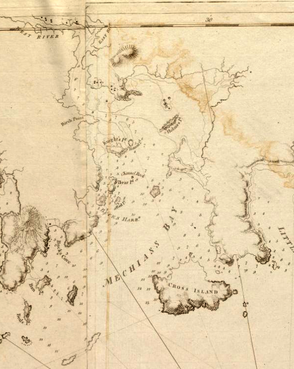
English: This is a detail of the source, which is a nautical chart captioned Coast of Maine from Moose Cove to Gouldsboro Bay. This detail shows only Machias Bay. The community of Machias is just visible at the top of the map. |
| Dáta | |
| Foinse |
From the Boston Public Library Digital Map collection (maps.bpl.org). Call Number: G1106.P5 1777 .D4 URL at time of upload: http://maps.bpl.org/details_12641/ |
| Údar | Des Barres, Joseph F.W. |
Ceadúnú
|
This work is in the public domain in its country of origin and other countries and areas where the copyright term is the author's life plus 100 years or fewer. | |
| This file has been identified as being free of known restrictions under copyright law, including all related and neighboring rights. | |
Stair chomhaid
Cliceáil ar dáta/am chun an comhad a radharc mar a bhí sé ag an am sin.
| Dáta/Am | Mionsamhail | Toisí | Úsáideoir | Nóta tráchta | |
|---|---|---|---|---|---|
| faoi láthair | 14:32, 12 Aibreán 2010 | | 600 × 753 (633 KB) | Magicpiano | Adjust color and contrast to improve readability. |
| 13:36, 26 Eanáir 2009 |  | 600 × 753 (489 KB) | Magicpiano | {{Information |Description={{en|1=This is a detail of the source, which is a nautical chart captioned ''Coast of Maine from Moose Cove to Gouldsboro Bay''. This detail shows only Machias Bay. The community of [[:en:Mach |
Úsáid comhaid
Tá nasc chuig an gcomhad seo ar na leathanaigh seo a leanas:
Global file usage
The following other wikis use this file:
- Úsáid ar en.wikipedia.org
- Úsáid ar fr.wikipedia.org
- Úsáid ar it.wikipedia.org
- Úsáid ar ja.wikipedia.org
- Úsáid ar pl.wikipedia.org
- Úsáid ar pt.wikipedia.org
- Úsáid ar ru.wikipedia.org
- Úsáid ar www.wikidata.org