Íomhá:‘Doh-Ray-Mee’ cottages in Raheny.jpg

Size of this preview: 800 × 285 picteilín. Other resolutions: 320 × 114 picteilín | 640 × 228 picteilín | 1,024 × 365 picteilín | 1,280 × 456 picteilín | 2,560 × 911 picteilín | 9,145 × 3,256 picteilín.
Taispeáin leagan ardtaifigh den íomhá (9,145 × 3,256 picteilín, méid comhaid: 4.93 MB, cineál MIME: image/jpeg)
| Seo comhad as An Cómhaoin Viciméid. Tá an tuairisc as an leathanach tuairisc Cómhaoin a leanas thíos.
|
Achoimriú
| Tuairisc |
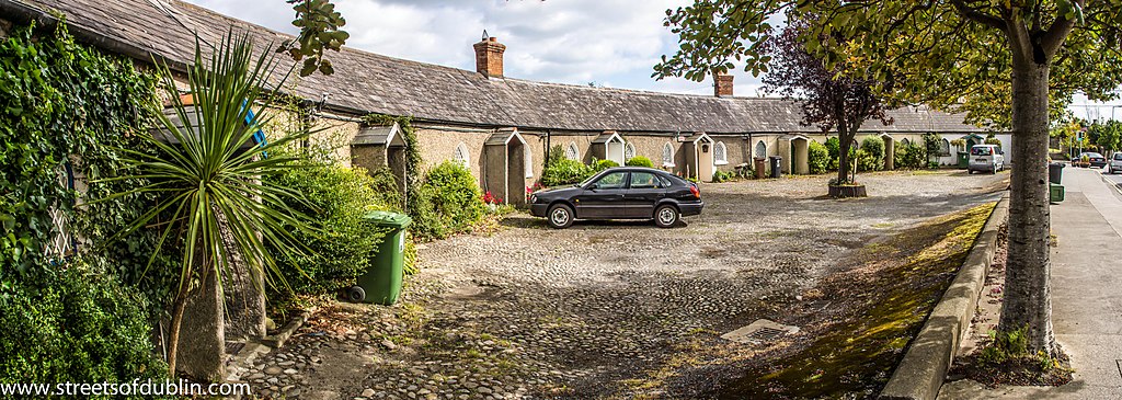
English: Do you know where the ‘Doh-Ray-Mee’ cottages in Raheny are? They are the row of cottages close to the village centre, down the hill where Raheny DART station is today. They are called ‘Doh-Ray-Mee’ cottages because there are eight cottages all together, just as there are eight notes on the musical scale. Their other name is ‘crescent cottages’ because they are built in a semi-circle called a crescent. The crescent cottages are among the oldest buildings in Raheny. They were built around 1790 by Samuel Dick, the Governor of the Bank of Ireland and a wealthy businessman. He lived on a large area of land in Raheny and built these eight houses for his workmen. Samuel Dick also built a school on Main Street beside the old graveyard of St Assam’s. It became known as ‘Dick’s Charity School’ because it was intended for ‘poor children of all persuasions’. This building, the oldest in Raheny, still stands today but is now a restaurant. When Samuel Dick died in 1802, his will stated that the rents the tenants paid for the crescent cottages should be used for the salary of the schoolmaster of his Charity School. Over time the cottages fell into disrepair and by 1879 were in such a poor state that Lord Ardilaun, the owner of St Anne’s estate, paid £375 to improve them all. In 1947 a terrible tragedy happened in one of the cottages: a gas leak killed Kathleen McKee, aged 11, and Hector McKee, aged 10. Luckily, the other six members of their family survived. The cottage closest to the Station House pub was once the village post office. The cottages have remained almost unchanged since they were built in the eighteenth century and people still live in them today. |
| Dáta | |
| Foinse | https://www.flickr.com/photos/infomatique/7986305640/ |
| Údar | William Murphy |
| Object location | | View this and other nearby images on: OpenStreetMap |
|---|
Ceadúnú
| This image was originally posted to Flickr by infomatique at https://www.flickr.com/photos/80824546@N00/7986305640. It was reviewed on 22 Meán Fómhair 2014 by FlickreviewR and was confirmed to be licensed under the terms of the cc-by-sa-2.0. |
This file is licensed under the Creative Commons Attribution-Share Alike 2.0 Generic license.
- Is féidir:
- an saothar seo a roinnt – an saothar seo a chóipeáil, a dháil amach, agus a tharchur
- an saothar seo a athmheascadh – an saothar seo a oiriúnú
- Ach amháin má leantar na coinníollacha seo a leanas:
- sannadh – Ní mor creidiúint a thabhairt leis an saothar, faoi mar a shonraigh an údar nó tabharthóir an ceadúnais (ach ná húsáid modh a thugann le fios go thacaíonn sé/sí tú féin nó an úsáid a bhaineann tú as an saothar).
- comhroinn araon – Má athraíonn tú nó síneann tú amach an saothar seo, ní féidir é a dháileadh ach amhaín faoin gceadúnas céanna nó ceann cosúil leis an gceann seo.

Stair chomhaid
Cliceáil ar dáta/am chun an comhad a radharc mar a bhí sé ag an am sin.
| Dáta/Am | Mionsamhail | Toisí | Úsáideoir | Nóta tráchta | |
|---|---|---|---|---|---|
| faoi láthair | 20:48, 22 Meán Fómhair 2014 | 9,145 × 3,256 (4.93 MB) | RTG | User created page with UploadWizard |
Úsáid comhaid
Tá nasc chuig an gcomhad seo ar na leathanaigh seo a leanas:
Global file usage
The following other wikis use this file:
- Úsáid ar en.wikipedia.org