Íomhá:Atafutrim.jpg

Size of this preview: 800 × 566 picteilín. Other resolutions: 320 × 226 picteilín | 640 × 452 picteilín | 1,024 × 724 picteilín | 1,280 × 905 picteilín | 2,088 × 1,476 picteilín.
Taispeáin leagan ardtaifigh den íomhá (2,088 × 1,476 picteilín, méid comhaid: 1.16 MB, cineál MIME: image/jpeg)
| Seo comhad as An Cómhaoin Viciméid. Tá an tuairisc as an leathanach tuairisc Cómhaoin a leanas thíos.
|
| Tuairisc |
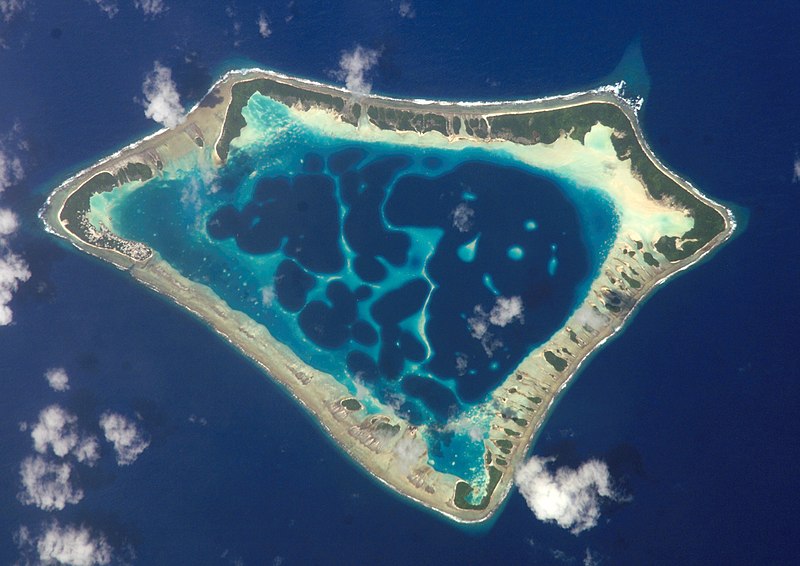
Cropped version of Atafu.jpg
|
| Dáta | (UTC) |
| Foinse | |
| Údar |
|
| Object location | | View this and other nearby images on: OpenStreetMap |
|---|
| Chruthaigh NASA an comhad seo, agus tógadh as suíomh Greasáin NASA nó foilseachán NASA é. Tá gach saothar den saghas sin sa fearann poiblí ach amháin an suaitheantas NASA, mar ní féidir saothair de chuid rialtas cónaidhme Stáit Aontaithe Mheiriceá a chur faoi chóipcheart. Féach ar an leathanach pholasaí cóipchirt NASA nó an leathanach pholasaí íomhanna JPL le tuilleadh eolais. | ||
 |
Rabhaidh:
|
Original upload log
This image is a derivative work of the following images:
- File:Atafu.jpg licensed with PD-USGov-NASA
Uploaded with derivativeFX

|
This image has been assessed under the valued image criteria and is considered the most valued image on Commons within the scope: Atafu atoll, Tokelau - satellite view. You can see its nomination here. |
Stair chomhaid
Cliceáil ar dáta/am chun an comhad a radharc mar a bhí sé ag an am sin.
| Dáta/Am | Mionsamhail | Toisí | Úsáideoir | Nóta tráchta | |
|---|---|---|---|---|---|
| faoi láthair | 00:12, 2 Márta 2009 | | 2,088 × 1,476 (1.16 MB) | Talkstosocks | {{Information |Description=Cropped version of Atafu.jpg *{{en|Satellite picture of the Atafu atoll in Tokelau.}} *{{es|Imágen de satélite de Atafu.}} *{{de|Satellitenbild des Atafu Atolls in Tokelau.}} |Source=*File:Atafu.jpg |Dat |
Úsáid comhaid
Tá nasc chuig an gcomhad seo ar na leathanaigh seo a leanas:
Global file usage
The following other wikis use this file:
- Úsáid ar ace.wikipedia.org
- Úsáid ar als.wikipedia.org
- Úsáid ar ar.wikipedia.org
- Úsáid ar bh.wikipedia.org
- Úsáid ar bn.wikipedia.org
- Úsáid ar bs.wikipedia.org
- Úsáid ar cs.wikipedia.org
- Úsáid ar de.wikipedia.org
- Úsáid ar el.wiktionary.org
- Úsáid ar en.wikipedia.org
- Úsáid ar en.wiktionary.org
- Úsáid ar es.wikipedia.org
- Úsáid ar es.wikibooks.org
- Úsáid ar eu.wikipedia.org
- Úsáid ar fa.wikipedia.org
- Úsáid ar fr.wikipedia.org
- Úsáid ar he.wikipedia.org
- Úsáid ar hi.wikipedia.org
- Úsáid ar ia.wikipedia.org
- Úsáid ar id.wikipedia.org
- Úsáid ar id.wiktionary.org
- Úsáid ar is.wikipedia.org
- Úsáid ar kbd.wikipedia.org
- Úsáid ar km.wikipedia.org
- Úsáid ar ko.wikipedia.org
- Úsáid ar ku.wiktionary.org
- Úsáid ar la.wikipedia.org
- Úsáid ar lv.wikipedia.org
- Úsáid ar mdf.wikipedia.org
- Úsáid ar mk.wikipedia.org
- Úsáid ar ml.wikipedia.org
- Úsáid ar ms.wikipedia.org
View more global usage of this file.