Íomhá:Baltimore neighborhoods map.png
Size of this preview: 529 × 599 picteilín. Other resolutions: 212 × 240 picteilín | 424 × 480 picteilín | 678 × 768 picteilín | 904 × 1,024 picteilín | 1,808 × 2,048 picteilín | 3,090 × 3,500 picteilín.
Taispeáin leagan ardtaifigh den íomhá (3,090 × 3,500 picteilín, méid comhaid: 2.92 MB, cineál MIME: image/png)
| Seo comhad as An Cómhaoin Viciméid. Tá an tuairisc as an leathanach tuairisc Cómhaoin a leanas thíos.
|
Achoimriú
| Tuairisc |
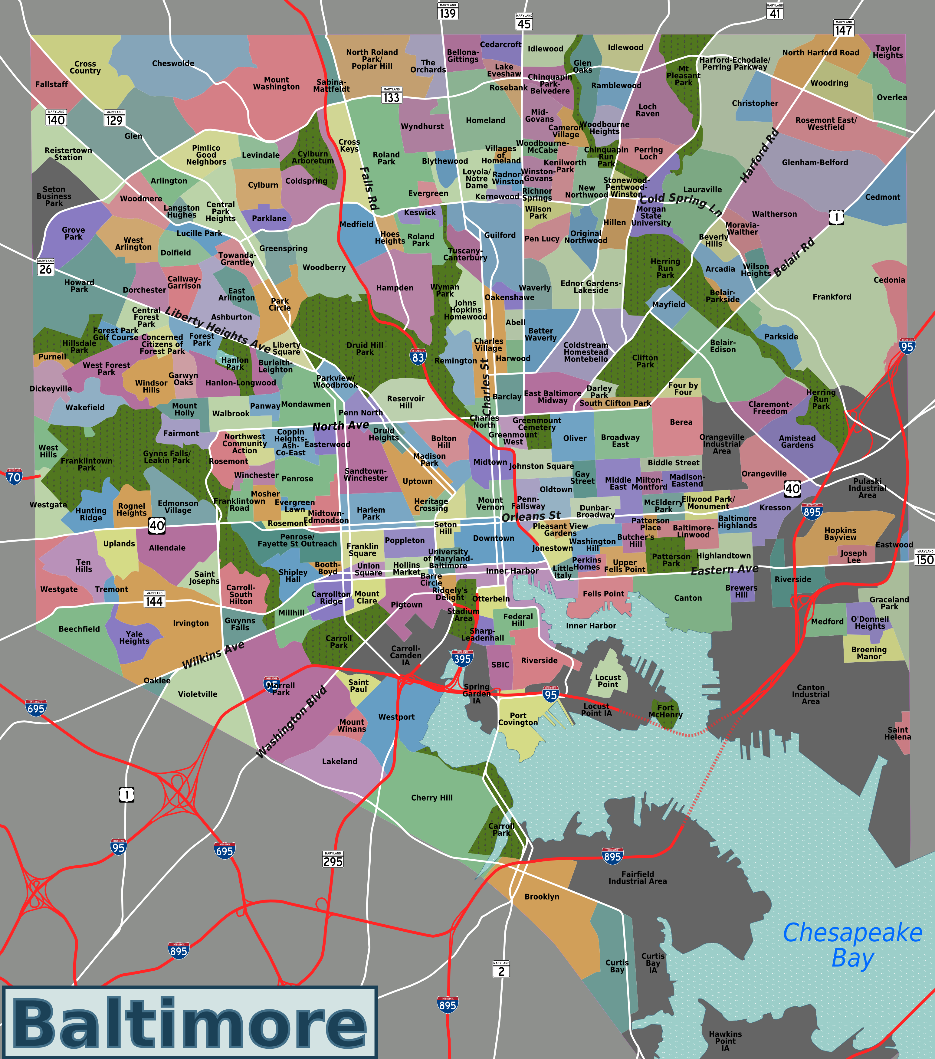
English: Map of Baltimore's neighborhoods, with official city-designated boundaries accurate to street level. |
| Dáta | |
| Foinse | self created, traced from OpenStreetMap |
| Údar | Peter Fitzgerald, OpenStreetMap |
This PNG is exported from a complex SVG available at Wikitravel Shared. Please make changes to this image by editing that SVG file & exporting a new version (or better yet, just contact me with proposed changes).
Ceadúnú
This file is licensed under the Creative Commons Attribution-Share Alike 3.0 Unported license.
- Is féidir:
- an saothar seo a roinnt – an saothar seo a chóipeáil, a dháil amach, agus a tharchur
- an saothar seo a athmheascadh – an saothar seo a oiriúnú
- Ach amháin má leantar na coinníollacha seo a leanas:
- sannadh – Ní mor creidiúint a thabhairt leis an saothar, faoi mar a shonraigh an údar nó tabharthóir an ceadúnais (ach ná húsáid modh a thugann le fios go thacaíonn sé/sí tú féin nó an úsáid a bhaineann tú as an saothar).
- comhroinn araon – Má athraíonn tú nó síneann tú amach an saothar seo, ní féidir é a dháileadh ach amhaín faoin gceadúnas céanna nó ceann cosúil leis an gceann seo.
Stair chomhaid
Cliceáil ar dáta/am chun an comhad a radharc mar a bhí sé ag an am sin.
| Dáta/Am | Mionsamhail | Toisí | Úsáideoir | Nóta tráchta | |
|---|---|---|---|---|---|
| faoi láthair | 07:26, 6 Eanáir 2010 | | 3,090 × 3,500 (2.92 MB) | Peterfitzgerald | {{Information |Description={{en|1=Map of Baltimore's neighborhoods, with official city-designated boundaries accurate to street level.}} |Source=self created, traced from [http://openstreetmap.org OpenStreetMap] |Author=[[User:Peterfitzgerald|Peter Fitzge |
Úsáid comhaid
Tá nasc chuig an gcomhad seo ar na leathanaigh seo a leanas:
Global file usage
The following other wikis use this file:
- Úsáid ar ca.wikipedia.org
- Úsáid ar en.wikipedia.org
- Úsáid ar en.wikivoyage.org
- Úsáid ar fa.wikipedia.org
- Úsáid ar fr.wikipedia.org
- Úsáid ar nl.wikipedia.org
- Úsáid ar ru.wikipedia.org
- Úsáid ar tr.wikipedia.org
- Úsáid ar vep.wikipedia.org