Íomhá:Cb-map.png
Níl aon taifeach is mó ar fáil.
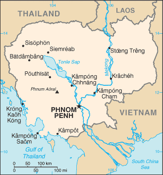
Cb-map.png (329 × 353 picteilín, méid comhaid: 13 KB, cineál MIME: image/png)
| Seo comhad as An Cómhaoin Viciméid. Tá an tuairisc as an leathanach tuairisc Cómhaoin a leanas thíos.
|
Achoimriú
| Tuairisc |
Català: Mapa de Cambodja.
Dansk: Phnom Penhs beliggenhed i Cambodja
English: Cambodia map from CIA World Factbook (since 11 Bealtaine 2005), converted from original GIF format
Esperanto: Mapo de Kamboĝo. Mapo pri Kamboĝo.
Español: Mapa de Camboya. Camboya.
Euskara: Kanputxeako mapa.
فارسی: کامبوج. نقشهٔ کامبوج.
Suomi: Kambodžan kartta.
עברית: מפה של קמבודיה.
日本語: カンボジアの地図.
Қазақша: Камбоджа қалалары.
ភាសាខ្មែរ: ផែនទីប្រទេសកម្ពុជា. Map of Cambodia. ផែនទីកម្ពុជា.
Lietuvių: Kambodžos žemėlapis.
Nederlands: Een overzichtskaart van Cambodja. Een overzichtskaart van Cambodja.
Norsk nynorsk: Kart over Kambodsja.
Kapampangan: Mapa ning Cambodia.
Português: Principais cidades do Camboja.
Русский: Города Камбоджи.
Simple English: Map of Cambodia.
Slovenčina: Mapa Kambodže.
Svenska: Engelskspråkig karta över Kambodja.
ไทย: เมืองต่างๆในประเทศกัมพูชา.
Türkçe: Kamboçya haritası.
Українська: Міста Камбоджі.
Tiếng Việt: Bản đồ Campuchia. Bản đồ Campuchia.
中文:柬埔寨地图. |
| Dáta | |
| Foinse |
CIA World Factbook |
| Údar | United States Central Intelligence Agency |
| Leaganacha eile |
|

|
This map image could be re-created using vector graphics as an SVG file. This has several advantages; see Commons:Media for cleanup for more information. If an SVG form of this image is available, please upload it and afterwards replace this template with
{{vector version available|new image name}}.
It is recommended to name the SVG file “Cb-map.svg”—then the template Vector version available (or Vva) does not need the new image name parameter. |
Ceadúnú
This image is in the public domain because it contains materials that originally came from the United States Central Intelligence Agency's World Factbook.
|
 |
Derivative works
Derivatives of 2005 map (shows Phú Quốc as part of Vietnam):
-
 Cambodia-map-blank.PNG
English -
 Cambodia-map-blank-russian.png
русский -
 Karte von Kambodscha - Basis CIA.png
Deutsch


Derivatives of 2002 map (shows Phú Quốc as part of Cambodia):
-
 Cb-map-ja.png
日本語 -
 Cb-map-mk.png
македонски


Stair chomhaid
Cliceáil ar dáta/am chun an comhad a radharc mar a bhí sé ag an am sin.
| Dáta/Am | Mionsamhail | Toisí | Úsáideoir | Nóta tráchta | |
|---|---|---|---|---|---|
| faoi láthair | 05:00, 2 Meán Fómhair 2011 | | 329 × 353 (13 KB) | Zyxw | updated version as of 11 May 2005 |
| 19:57, 20 Meitheamh 2005 |  | 330 × 355 (12 KB) | Andrew pmk~commonswiki | losslessly compressed with optipng | |
| 19:46, 28 Feabhra 2005 |  | 330 × 355 (13 KB) | Alfio | CIA map of Cambodia |
Úsáid comhaid
Níl nasc ó aon leathanach eile don íomhá seo.
Global file usage
The following other wikis use this file:
- Úsáid ar ar.wikipedia.org
- Úsáid ar az.wikipedia.org
- Úsáid ar be-tarask.wikipedia.org
- Úsáid ar bh.wikipedia.org
- Úsáid ar blk.wikipedia.org
- Úsáid ar bn.wikipedia.org
- Úsáid ar ca.wikipedia.org
- Úsáid ar ckb.wikipedia.org
- Úsáid ar cy.wikipedia.org
- Úsáid ar de.wikipedia.org
- Úsáid ar dsb.wikipedia.org
- Úsáid ar el.wikipedia.org
- Úsáid ar en.wikipedia.org
- Úsáid ar en.wikinews.org
- Úsáid ar en.wikiversity.org
- Úsáid ar eo.wikipedia.org
- Úsáid ar eu.wikipedia.org
- Úsáid ar fa.wikipedia.org
- Úsáid ar fi.wikipedia.org
- Úsáid ar fr.wikipedia.org
- Úsáid ar fr.wikinews.org
- Úsáid ar gl.wikipedia.org
- Úsáid ar he.wikipedia.org
View more global usage of this file.