Íomhá:Cuban crisis map missile range.jpg
Size of this preview: 603 × 599 picteilín. Other resolutions: 241 × 240 picteilín | 483 × 480 picteilín | 666 × 662 picteilín.
Taispeáin leagan ardtaifigh den íomhá (666 × 662 picteilín, méid comhaid: 198 KB, cineál MIME: image/jpeg)
| Seo comhad as An Cómhaoin Viciméid. Tá an tuairisc as an leathanach tuairisc Cómhaoin a leanas thíos.
|

|
This file has been superseded by The relative ranges of the IL-28, SS-4, and SS-5, stationed on Cuba.png. It is recommended to use the other file. Please note that deleting superseded images requires consent. Reason to use the other file: "A PNG version of this file is now available."
|

|
| Tuairisc |
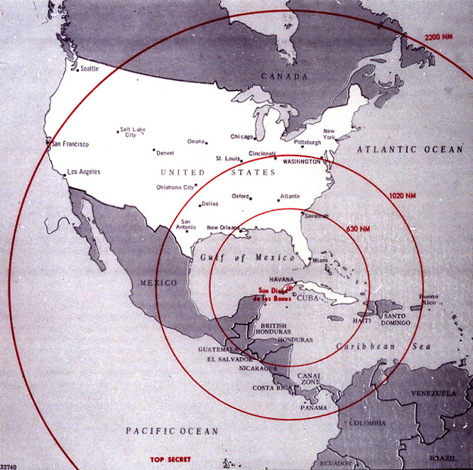
English: Map of Northern America showing the full range of the nuclear missiles under construction in Cuba, used during the secret meetings on the Cuban crisis. Deutsch: Diese Karte der westlichen Hemisphäre zeigt die volle Reichweite der Atomraketen, die auf Kuba im Rahmen der Kubakrise stationiert werden sollten bzw. worden sind. Diese Karte wurde bei den geheimen Treffen während der Kubakrise verwendet. Die Karte war ehemals Top Secret. Die eingezeichneten Radien sind in Nautischen Meilen (1 NM ~ 1,852 km) bemaßt; die 1020 NM (~ 1900 km) entsprechen ungefähr der taktischen Reichweite der SS-4, die 2200 NM (~ 4000 km) jener der SS-5. |
|||
| Dáta | ||||
| Foinse | The John F. Kennedy Presidential Library and Museum, Boston. [1] | |||
| Údar | CIA | |||
| Ceadúnas (Athúsáid a bhaint as an gcomhad seo) |
|

![[1]](http://www.jfklibrary.org/jfkl/cmc/cmc_map_missile_range.jpg)
Stair chomhaid
Cliceáil ar dáta/am chun an comhad a radharc mar a bhí sé ag an am sin.
| Dáta/Am | Mionsamhail | Toisí | Úsáideoir | Nóta tráchta | |
|---|---|---|---|---|---|
| faoi láthair | 21:18, 8 Eanáir 2009 | | 666 × 662 (198 KB) | PaulBommel | {{Information |Description= |Source= |Date= |Author= |Permission= |other_versions= }} |
| 16:31, 9 Meitheamh 2007 |  | 700 × 920 (249 KB) | Nickel Chromo~commonswiki | {{Information| |Description= '''English''': Map of the western hemisphere showing the full range of the nuclear missiles under construction in Cuba, used during the secret meetings on the Cuban crisis. |Source= The John F. Kennedy Presidential Library and |
Úsáid comhaid
Tá nasc chuig an gcomhad seo ar na leathanaigh seo a leanas:
Global file usage
The following other wikis use this file:
- Úsáid ar ar.wikipedia.org
- Úsáid ar ba.wikipedia.org
- Úsáid ar bg.wikipedia.org
- Úsáid ar da.wikipedia.org
- Úsáid ar en.wikipedia.org
- Úsáid ar en.wikiquote.org
- Úsáid ar eo.wikipedia.org
- Úsáid ar es.wikipedia.org
- Úsáid ar fi.wikipedia.org
- Úsáid ar fi.wikibooks.org
- Úsáid ar hr.wikipedia.org
- Úsáid ar it.wikipedia.org
- Úsáid ar lv.wikipedia.org
- Úsáid ar no.wikibooks.org
- Úsáid ar rm.wikipedia.org
- Úsáid ar ro.wikipedia.org
- Úsáid ar ru.wikipedia.org
- Úsáid ar sr.wikipedia.org
- Úsáid ar sv.wikipedia.org
- Úsáid ar th.wikipedia.org
- Úsáid ar uk.wikipedia.org