Íomhá:DG Ariel Plantation.jpg

Size of this preview: 750 × 600 picteilín. Other resolutions: 300 × 240 picteilín | 600 × 480 picteilín | 960 × 768 picteilín | 1,280 × 1,024 picteilín | 1,500 × 1,200 picteilín.
Taispeáin leagan ardtaifigh den íomhá (1,500 × 1,200 picteilín, méid comhaid: 162 KB, cineál MIME: image/jpeg)
| Seo comhad as An Cómhaoin Viciméid. Tá an tuairisc as an leathanach tuairisc Cómhaoin a leanas thíos.
|
Achoimriú
| Tuairisc |
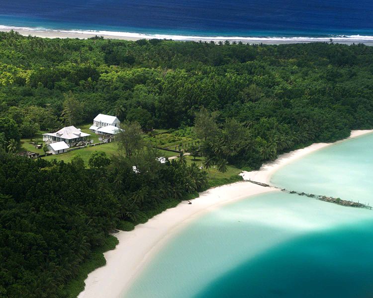
English: Aerial photograph of the coconut plantation at East Point, Diego Garcia. Photograph shows strip of land between both ocean and lagoon.
The island hosts a large airstrip used by the U.S. Armed forces during the Gulf war for operating B-52s. U.S. Submarines and Navy Seal teams have also populated the island in the past. In 1986 The USS Saratoga (CV 60) was docked at the island when it was called away to respond to threats by Lybian Leader Momar Kadaffi and the "Line of Death" in the Gulf of Sidra (also known as the Gulf of Sirte). The carrier left its port while many of its ±4500 sailors were still on the island, which subsequently had to be airlifted via helicopter as the ship made its way to the Mediterranean. The Saratoga spearheaded the assault on the African Nation. |
| Foinse | |
| Údar |
Ceadúnú
This work is in the public domain in the United States because it is a work prepared by an officer or employee of the United States Government as part of that person’s official duties under the terms of Title 17, Chapter 1, Section 105 of the US Code.
Note: This only applies to original works of the Federal Government and not to the work of any individual U.S. state, territory, commonwealth, county, municipality, or any other subdivision. This template also does not apply to postage stamp designs published by the United States Postal Service since 1978. (See § 313.6(C)(1) of Compendium of U.S. Copyright Office Practices). It also does not apply to certain US coins; see The US Mint Terms of Use.
|
 | |
| This file has been identified as being free of known restrictions under copyright law, including all related and neighboring rights. | ||
Original upload log
The original description page was here. All following user names refer to en.wikipedia.
- 2005-12-27 07:37 Jgrimmer 1500×1200×8 (166195 bytes) Ariel photograph of the coconut plantation at East Point, Diego Garcia. Photograph shows stip of land between both ocean and lagoon.
Stair chomhaid
Cliceáil ar dáta/am chun an comhad a radharc mar a bhí sé ag an am sin.
| Dáta/Am | Mionsamhail | Toisí | Úsáideoir | Nóta tráchta | |
|---|---|---|---|---|---|
| faoi láthair | 13:00, 20 Aibreán 2008 | | 1,500 × 1,200 (162 KB) | File Upload Bot (Magnus Manske) | {{BotMoveToCommons|en.wikipedia}} {{Information |Description={{en|Aerial photograph of the coconut plantation at East Point, Diego Garcia. Photograph shows strip of land between both ocean and lagoon. The island hosts a large airstrip used by the U.S. |
Úsáid comhaid
Tá nasc chuig an gcomhad seo ar na leathanaigh seo a leanas:
Global file usage
The following other wikis use this file:
- Úsáid ar ast.wikipedia.org
- Úsáid ar be.wikipedia.org
- Úsáid ar ca.wikipedia.org
- Úsáid ar ceb.wikipedia.org
- Úsáid ar cy.wikipedia.org
- Úsáid ar en.wikipedia.org
- Úsáid ar eo.wikipedia.org
- Úsáid ar es.wikipedia.org
- Úsáid ar fa.wikipedia.org
- Úsáid ar fr.wikipedia.org
- Úsáid ar gl.wikipedia.org
- Úsáid ar he.wikipedia.org
- Úsáid ar hi.wikipedia.org
- Úsáid ar it.wikipedia.org
- Úsáid ar mk.wikipedia.org
- Úsáid ar ml.wikipedia.org
- Úsáid ar mn.wikipedia.org
- Úsáid ar ne.wikipedia.org
- Úsáid ar nl.wikipedia.org
- Úsáid ar no.wikipedia.org
- Úsáid ar os.wikipedia.org
- Úsáid ar pt.wikipedia.org
- Úsáid ar sh.wikipedia.org
- Úsáid ar simple.wikipedia.org
- Úsáid ar sr.wikipedia.org
- Úsáid ar ta.wikipedia.org
- Úsáid ar uk.wikipedia.org
- Úsáid ar www.wikidata.org
- Úsáid ar zh.wikipedia.org