Íomhá:First century Iudaea province.gif
Taispeáin leagan ardtaifigh den íomhá(575 × 792 picteilín, méid comhaid: 31 KB, cineál MIME: image/gif)

Seo comhad as An Cómhaoin Viciméid. Tá an tuairisc as an leathanach tuairisc Cómhaoin a leanas thíos.
Is stór comhaid meáin Saor é an Cómhaoin Viciméid. Is féidir leat cabhrú.
This map image could be re-created using vector graphics as an SVG file. This has several advantages; see Commons:Media for cleanup for more information. If an SVG form of this image is available, please upload it and afterwards replace this template with {{vector version available|new image name}}.


It is recommended to name the SVG file “First century Iudaea province.svg”—then the template Vector version available (or Vva) does not need the new image name parameter.

Achoimriú

Tuairisc
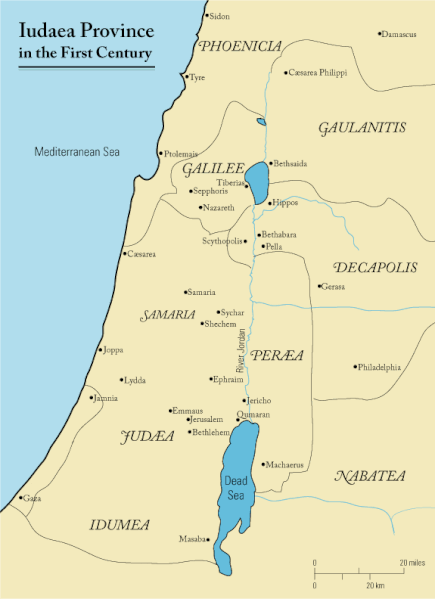
English: This is a map of first century Iudaea Province that I created using Illustrator CS2. I traced this image for the general geographic features. I then manually input data from maps found in a couple of sources.
  • Robert W. Funk and the Jesus Seminar. The Acts of Jesus. HarperSanFrancisco: 1998. p. xxiv.
  • Michael Grant. Jesus: An Historian's Review of the Gospels. Charles Scribner's Sons: 1977. p. 65-67.
  • John P. Meier. A Marginal Jew. Doubleday: 1991. p. 1:434.
Dáta 23 Márta 2006 (original upload date)
Foinse Transferred from en.wikipedia to Commons.
Údar Andrew c ar an Vicipéid Béarla
Ceadúnas
(Athúsáid a bhaint as an gcomhad seo)
Released under the GNU Free Documentation License or CC-BY.
Leaganacha eile العربيَّة

Ceadúnú

Is mise Andrew c from en.wikipedia.org, sealbhóir cóipchirt an shaothair seo, agus foilsím é faoi na ceadúnais seo a leanas:
GNU head Tugtar cead an doiciméad seo a chóipeáil, a dháileadh agus/nó a mhodhnú faoi théarmaí an Ceadúnas Doiciméadúcháin Saor ó GNU, Leagan 1.2 nó aon leagan níos déanaí a d’fhoilsigh an Fondúireacht Bogearraí Saor in Aisce; gan aon Rannóga Inmheánacha, gan aon Téacsanna Clúdaigh Tosaigh, agus gan aon Téacsanna Clúdaigh Cúil. Tá cóip den cheadúnas san áireamh sa chuid dar teideal Ceadúnas Doiciméadúcháin Saor ó GNU. Faoi réir ag séanaidh ginearálta.
w:ga:Creative Commons
sannadh
This file is licensed under the Creative Commons Attribution 3.0 Unported license.
Creidiúint: Wikipedia User:Andrew c
Is féidir:
  • an saothar seo a roinnt – an saothar seo a chóipeáil, a dháil amach, agus a tharchur
  • an saothar seo a athmheascadh – an saothar seo a oiriúnú
Ach amháin má leantar na coinníollacha seo a leanas:
  • sannadh – Ní mor creidiúint a thabhairt leis an saothar, faoi mar a shonraigh an údar nó tabharthóir an ceadúnais (ach ná húsáid modh a thugann le fios go thacaíonn sé/sí tú féin nó an úsáid a bhaineann tú as an saothar).
Public domain I, the copyright holder of this work, release this work into the public domain. This applies worldwide.
In some countries this may not be legally possible; if so:
I grant anyone the right to use this work for any purpose, without any conditions, unless such conditions are required by law.

Original upload log

The original description page was here. All following user names refer to en.wikipedia.
  • 2006-03-24 18:48 Andrew c 575×792×8 (32374 bytes) This is a map of First Century Palestine that I created using Illustrator CS2. I traced [http://commons.wikimedia.org/wiki/Image:Map_of_administrative_regions_in_Israel.png this] image for the general geographic features. I then manually input data from m
  • 2006-03-23 19:48 Andrew c 587×790×8 (30752 bytes) This is a map of First Century Palestine that I created using Illustrator CS2. I traced [http://commons.wikimedia.org/wiki/Image:Map_of_administrative_regions_in_Israel.png this] image for the general geographic features. I then manually input data from m

Captions

Add a one-line explanation of what this file represents
Judaea province in the 1st Century CE

Items portrayed in this file

taispeánann sé/sí

23 Márta 2006

MIME type Béarla

image/gif

checksum Béarla

e488e0183049d2138c916ccc7a24c107807f12b7

determination method Béarla: SHA-1 Béarla

data size Béarla

32,019 Beart

792 picteilín

575 picteilín

Stair chomhaid

Cliceáil ar dáta/am chun an comhad a radharc mar a bhí sé ag an am sin.

Dáta/AmMionsamhailToisíÚsáideoirNóta tráchta
faoi láthair11:47, 18 Meán Fómhair 2011Mionsamhail do leagan ó 11:47, 18 Meán Fómhair 2011575 × 792 (31 KB)OnceinawhileRemoved region-name "Philistia", as incorrect
14:05, 13 Meán Fómhair 2007Mionsamhail do leagan ó 14:05, 13 Meán Fómhair 2007575 × 792 (32 KB)Liftarn{{SVG|map}} {{Information |Description=This is a map of first century en:Iudaea Province that I created using Illustrator CS2. I traced [http://commons.wikimedia.org/wiki/Image:Map_of_administrative_regions_in_Israel.png this] image for the general g
00:29, 30 Aibreán 2006Mionsamhail do leagan ó 00:29, 30 Aibreán 2006575 × 792 (32 KB)Duende~commonswikihttp://en.wikipedia.org/wiki/Image:First_century_palestine.gif

Tá nasc chuig an gcomhad seo ar 2 an leathanach seo a leanas:

Global file usage

The following other wikis use this file:

View more global usage of this file.