Íomhá:France 1154-fr.png

Size of this preview: 474 × 600 picteilín. Other resolutions: 190 × 240 picteilín | 379 × 480 picteilín | 607 × 768 picteilín | 1,226 × 1,551 picteilín.
Taispeáin leagan ardtaifigh den íomhá (1,226 × 1,551 picteilín, méid comhaid: 68 KB, cineál MIME: image/png)
| Seo comhad as An Cómhaoin Viciméid. Tá an tuairisc as an leathanach tuairisc Cómhaoin a leanas thíos.
|
Achoimriú
| Tuairisc |
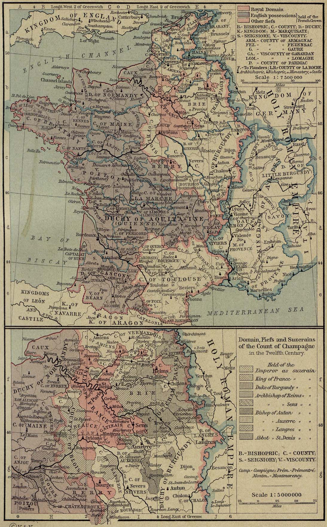
English: French map of the growth of the Plantagenet Empire, from 1144 to 1166.. Français : Carte en français de l'expansion de l'empire Plantagenêt, de 1144 à 1166.. |
|||
| Dáta | ||||
| Foinse |
Obair féin. Based on
|
|||
| Údar | Sémhur (talk) | |||
| Leaganacha eile |
[]
|


| Camera location | | View this and other nearby images on: OpenStreetMap |
|---|
Ceadúnú
Is mise sealbhóir cóipchirt an shaothair seo agus foilsím é faoi na ceadúnais seo a leanas:

|
Tugtar cead an doiciméad seo a chóipeáil, a dháileadh agus/nó a mhodhnú faoi théarmaí an Ceadúnas Doiciméadúcháin Saor ó GNU, Leagan 1.2 nó aon leagan níos déanaí a d’fhoilsigh an Fondúireacht Bogearraí Saor in Aisce; gan aon Rannóga Inmheánacha, gan aon Téacsanna Clúdaigh Tosaigh, agus gan aon Téacsanna Clúdaigh Cúil. Tá cóip den cheadúnas san áireamh sa chuid dar teideal Ceadúnas Doiciméadúcháin Saor ó GNU. |
This file is licensed under the Creative Commons Attribution-Share Alike 3.0 Unported, 2.5 Generic, 2.0 Generic and 1.0 Generic license.
- Is féidir:
- an saothar seo a roinnt – an saothar seo a chóipeáil, a dháil amach, agus a tharchur
- an saothar seo a athmheascadh – an saothar seo a oiriúnú
- Ach amháin má leantar na coinníollacha seo a leanas:
- sannadh – Ní mor creidiúint a thabhairt leis an saothar, faoi mar a shonraigh an údar nó tabharthóir an ceadúnais (ach ná húsáid modh a thugann le fios go thacaíonn sé/sí tú féin nó an úsáid a bhaineann tú as an saothar).
- comhroinn araon – Má athraíonn tú nó síneann tú amach an saothar seo, ní féidir é a dháileadh ach amhaín faoin gceadúnas céanna nó ceann cosúil leis an gceann seo.
Is féidir leat a roghnú an ceadúnas do rogha
Stair chomhaid
Cliceáil ar dáta/am chun an comhad a radharc mar a bhí sé ag an am sin.
| Dáta/Am | Mionsamhail | Toisí | Úsáideoir | Nóta tráchta | |
|---|---|---|---|---|---|
| faoi láthair | 15:18, 7 Meán Fómhair 2007 | | 1,226 × 1,551 (68 KB) | Sémhur | {{Information |Description= {{fr|Carte en français de l'expansion de l'empire Plantagenêt, de 1144 à 1166.}} {{en|French map of the growth of the Plantagenet Empire, from 1144 to 1166.}} |Source=Own work - Travail personnel<br/> Based on [[:Image:Franc |
Úsáid comhaid
Níl nasc ó aon leathanach eile don íomhá seo.
Global file usage
The following other wikis use this file:
- Úsáid ar br.wikipedia.org
- Úsáid ar de.wikipedia.org
- Úsáid ar fr.wikipedia.org