Íomhá:French Algeria evolution 1830-1962 map-fr.svg

Size of this PNG preview of this SVG file: 604 × 600 picteilín. Other resolutions: 242 × 240 picteilín | 483 × 480 picteilín | 773 × 768 picteilín | 1,031 × 1,024 picteilín | 2,062 × 2,048 picteilín | 1,287 × 1,278 picteilín.
Taispeáin leagan ardtaifigh den íomhá (Comhad SVG, ainmniúil 1,287 × 1,278 picteilíni, méid comhaid: 1.86 MB)
| Seo comhad as An Cómhaoin Viciméid. Tá an tuairisc as an leathanach tuairisc Cómhaoin a leanas thíos.
|
Achoimriú
| Tuairisc |
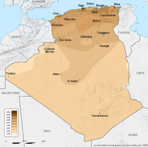
English: French Algeria evolution map, from 1830 to 1962.
Français : Carte montrant l'évolution territoriale de l'Algérie française, de 1830 à 1962.
|
| Dáta | (UTC) |
| Foinse |
English:
Français :
|
| Údar | Sémhur |
| Leaganacha eile |
Derivative works of this file: French Algeria evolution 1830-1962 map-es.svg |
| Creidiúint (required by the license) | © Sémhur / Wikimedia Commons / |
| SVG genesis |
| Camera location | | View this and other nearby images on: OpenStreetMap |
|---|
Ceadúnú
Is mise sealbhóir cóipchirt an shaothair seo agus foilsím é faoi na ceadúnais seo a leanas:
| Copyleft: This work of art is free; you can redistribute it and/or modify it according to terms of the Free Art License. You will find a specimen of this license on the Copyleft Attitude site as well as on other sites. |
This file is licensed under the Creative Commons Attribution-Share Alike 4.0 International, 3.0 Unported, 2.5 Generic, 2.0 Generic and 1.0 Generic license.
- Is féidir:
- an saothar seo a roinnt – an saothar seo a chóipeáil, a dháil amach, agus a tharchur
- an saothar seo a athmheascadh – an saothar seo a oiriúnú
- Ach amháin má leantar na coinníollacha seo a leanas:
- sannadh – Ní mor creidiúint a thabhairt leis an saothar, faoi mar a shonraigh an údar nó tabharthóir an ceadúnais (ach ná húsáid modh a thugann le fios go thacaíonn sé/sí tú féin nó an úsáid a bhaineann tú as an saothar).
- comhroinn araon – Má athraíonn tú nó síneann tú amach an saothar seo, ní féidir é a dháileadh ach amhaín faoin gceadúnas céanna nó ceann cosúil leis an gceann seo.
Is féidir leat a roghnú an ceadúnas do rogha
Original upload log
This image is a derivative work of the following images:
- File:Algeria_location_map.svg licensed with Cc-by-sa-3.0, GFDL
- 2009-11-17T12:51:26Z Sting 1287x1278 (372657 Bytes) == {{int:filedesc}} == {{Location|28|19|00|N|1|39|00|E|scale:8000000}} {{Information |Description={{en|Blank administrative map of [[:en:Algeria|Algeria]], for geo-location purposes.}} {{fr|Carte administrative vierge de l'[
Uploaded with derivativeFX
Stair chomhaid
Cliceáil ar dáta/am chun an comhad a radharc mar a bhí sé ag an am sin.
| Dáta/Am | Mionsamhail | Toisí | Úsáideoir | Nóta tráchta | |
|---|---|---|---|---|---|
| faoi láthair | 19:34, 22 Bealtaine 2014 | | 1,287 × 1,278 (1.86 MB) | Sémhur | Valid SVG |
| 18:57, 29 Meán Fómhair 2012 |  | 1,287 × 1,278 (1.86 MB) | Sémhur | == {{int:filedesc}} == {{Information |Description={{Multilingual description |en= en:French Algeria evolution map, from 1830 to 1962. |fr= Carte de l'fr:Algérie française, de 1830 à 1962. }} <br/> Scale: 1:6,800,000 (precision: 1,700 m)... |
Úsáid comhaid
Tá nasc chuig an gcomhad seo ar na leathanaigh seo a leanas:
Global file usage
The following other wikis use this file:
- Úsáid ar ast.wikipedia.org
- Úsáid ar bg.wikipedia.org
- Úsáid ar ca.wikipedia.org
- Úsáid ar da.wikipedia.org
- Úsáid ar de.wikipedia.org
- Úsáid ar en.wikipedia.org
- Úsáid ar eu.wikipedia.org
- Úsáid ar fa.wikipedia.org
- Úsáid ar fi.wikipedia.org
- Úsáid ar fr.wikipedia.org
- Úsáid ar hy.wikipedia.org
- Úsáid ar id.wikipedia.org
- Úsáid ar it.wikipedia.org
- Úsáid ar ja.wikipedia.org
- Úsáid ar ka.wikipedia.org
- Úsáid ar ko.wikipedia.org
- Úsáid ar lt.wikipedia.org
- Úsáid ar lv.wikipedia.org
- Úsáid ar mk.wikipedia.org
- Úsáid ar ms.wikipedia.org
- Úsáid ar mt.wikipedia.org
- Úsáid ar nl.wikipedia.org
- Úsáid ar pl.wikipedia.org
- Úsáid ar pnb.wikipedia.org
- Úsáid ar pt.wikipedia.org
- Úsáid ar ro.wikipedia.org
- Úsáid ar ru.wikipedia.org
View more global usage of this file.