Íomhá:Indus.A2002274.0610.1km.jpg

Size of this preview: 458 × 599 picteilín. Other resolutions: 183 × 240 picteilín | 367 × 480 picteilín | 587 × 768 picteilín | 783 × 1,024 picteilín | 1,300 × 1,700 picteilín.
Taispeáin leagan ardtaifigh den íomhá (1,300 × 1,700 picteilín, méid comhaid: 480 KB, cineál MIME: image/jpeg)
Stair chomhaid
Cliceáil ar dáta/am chun an comhad a radharc mar a bhí sé ag an am sin.
| Dáta/Am | Mionsamhail | Toisí | Úsáideoir | Nóta tráchta | |
|---|---|---|---|---|---|
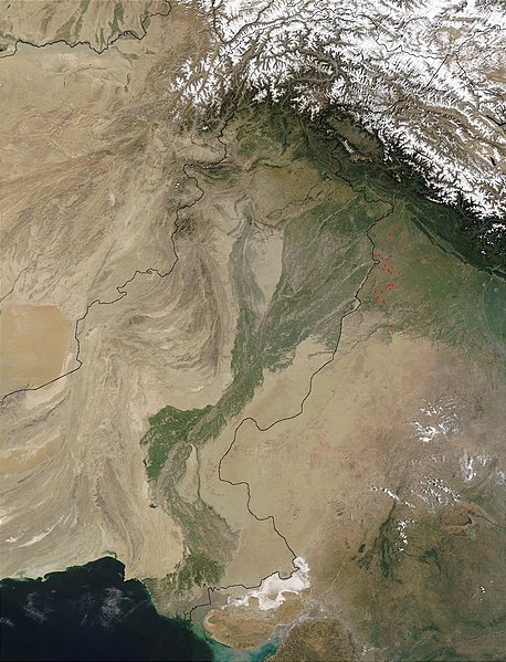
| faoi láthair | 13:03, 28 Márta 2008 |  | 1,300 × 1,700 (480 KB) | File Upload Bot (Magnus Manske) | {{BotMoveToCommons|en.wikipedia}} {{Information |Description={{en|en:Satellite image of the en:Indus River basin. Red dots indicate fires. International boundaries are superimposed; the boundary through en:Jammu and Kashmir reflects the [[ |
Úsáid comhaid
Níl nasc ó aon leathanach eile don íomhá seo.
Global file usage
The following other wikis use this file:
- Úsáid ar af.wikipedia.org
- Úsáid ar ar.wikipedia.org
- Úsáid ar arz.wikipedia.org
- Úsáid ar ast.wikipedia.org
- Úsáid ar as.wikipedia.org
- Úsáid ar azb.wikipedia.org
- Úsáid ar az.wikipedia.org
- Úsáid ar ba.wikipedia.org
- Úsáid ar be-tarask.wikipedia.org
- Úsáid ar bh.wikipedia.org
- Úsáid ar bn.wikipedia.org
- Úsáid ar bo.wikipedia.org
- Úsáid ar br.wikipedia.org
- Úsáid ar bxr.wikipedia.org
- Úsáid ar ca.wikipedia.org
- Úsáid ar ceb.wikipedia.org
- Úsáid ar ce.wikipedia.org
- Úsáid ar ckb.wikipedia.org
- Úsáid ar cy.wikipedia.org
- Úsáid ar da.wikipedia.org
- Úsáid ar en.wikipedia.org
- Úsáid ar eo.wikipedia.org
- Úsáid ar es.wikipedia.org
- Úsáid ar fa.wikipedia.org
- Úsáid ar fiu-vro.wikipedia.org
- Úsáid ar gd.wikipedia.org
- Úsáid ar gl.wikipedia.org
- Úsáid ar hi.wikipedia.org
- Úsáid ar hy.wikipedia.org
- Úsáid ar ia.wikipedia.org
- Úsáid ar id.wikipedia.org
- Úsáid ar ilo.wikipedia.org
- Úsáid ar incubator.wikimedia.org
- Úsáid ar is.wikipedia.org
- Úsáid ar it.wikipedia.org
View more global usage of this file.

