Íomhá:Map of the Arctic region showing the Northeast Passage, the Northern Sea Route and Northwest Passage, and bathymetry.png

Size of this preview: 632 × 600 picteilín. Other resolutions: 253 × 240 picteilín | 506 × 480 picteilín | 1,003 × 952 picteilín.
Taispeáin leagan ardtaifigh den íomhá (1,003 × 952 picteilín, méid comhaid: 758 KB, cineál MIME: image/png)
| Seo comhad as An Cómhaoin Viciméid. Tá an tuairisc as an leathanach tuairisc Cómhaoin a leanas thíos.
|
Achoimriú
| Tuairisc |
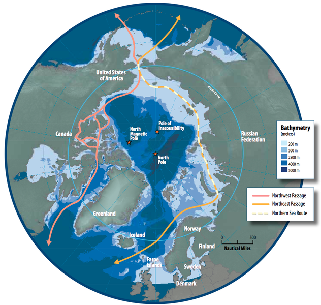
English: Map of the Arctic region showing shipping routes Northeast Passage, Northern Sea Route, and Northwest Passage, and bathymetry |
| Dáta | |
| Foinse | Arctic Council - Arctic marine shipping assessment - http://www.arctic.noaa.gov/detect/documents/AMSA_2009_Report_2nd_print.pdf |
| Údar | Susie Harder |
Ceadúnú
This file is in the public domain because the work was created/published by the Arctic Council, an international organization
|
Stair chomhaid
Cliceáil ar dáta/am chun an comhad a radharc mar a bhí sé ag an am sin.
| Dáta/Am | Mionsamhail | Toisí | Úsáideoir | Nóta tráchta | |
|---|---|---|---|---|---|
| faoi láthair | 16:46, 19 Deireadh Fómhair 2014 | | 1,003 × 952 (758 KB) | Al83tito | User created page with UploadWizard |
Úsáid comhaid
Níl nasc ó aon leathanach eile don íomhá seo.
Global file usage
The following other wikis use this file:
- Úsáid ar bn.wikipedia.org
- Úsáid ar de.wikipedia.org
- Úsáid ar en.wikipedia.org
- Úsáid ar es.wikipedia.org
- Úsáid ar fa.wikipedia.org
- Úsáid ar fr.wikipedia.org
- Úsáid ar he.wikipedia.org
- Úsáid ar hr.wikipedia.org
- Úsáid ar hu.wikipedia.org
- Úsáid ar id.wikipedia.org
- Úsáid ar it.wikipedia.org
- Úsáid ar ja.wikipedia.org
- Úsáid ar ko.wikipedia.org
- Úsáid ar nl.wikipedia.org
- Úsáid ar pl.wikipedia.org
- Úsáid ar pt.wikipedia.org
- Úsáid ar ru.wikipedia.org
- Úsáid ar sd.wikipedia.org
- Úsáid ar te.wikipedia.org
- Úsáid ar th.wikipedia.org
- Úsáid ar tr.wikipedia.org