Íomhá:Mordovia03.png

Size of this preview: 800 × 510 picteilín. Other resolutions: 320 × 204 picteilín | 640 × 408 picteilín | 810 × 516 picteilín.
Taispeáin leagan ardtaifigh den íomhá (810 × 516 picteilín, méid comhaid: 39 KB, cineál MIME: image/png)
| Seo comhad as An Cómhaoin Viciméid. Tá an tuairisc as an leathanach tuairisc Cómhaoin a leanas thíos.
|
Achoimriú
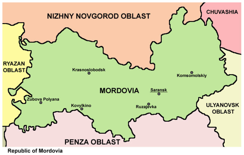
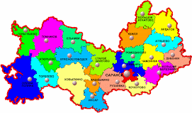
- Map of the Republic of Mordovia.
Source and license

|
This map has been uploaded by Electionworld from en.wikipedia.org to enable the |
Map made by PANONIAN
| This work has been released into the public domain by its author, PANONIAN. This applies worldwide. In some countries this may not be legally possible; if so: |
References
Maps from external links:
- http://proektdm.ru/geo/mordovia-map.jpg
- http://www.posztinfo.hu/upload/2/270fda34ba718128aa7246deb5102fb3_Mordovia.jpg
- http://www.mapzones.com/citymap/russia/republic_of_mordovia/republic_of_mordovia.jpg
- http://openbudget.karelia.ru/budnord/russian/volga-vyatsky/mordovia-republic/images/karta_mordovia.jpg
- http://www.rdaward.org/map/4u.jpg
- http://www.zum.de/whkmla/histatlas/russia/mordovia.gif
- http://files.vector-images.com/clipart/mordovia_map.gif
- http://www.mccme.ru/putevod/13/mordoveng.gif
- http://1.bp.blogspot.com/_i_q3O2fWjm4/TOh-JUeRF1I/AAAAAAAAAHc/-ts988pFOV4/s1600/mordovia.jpg
- http://1.bp.blogspot.com/_ahYgF9jmiCw/R0SPR-8nhEI/AAAAAAAAAIc/_oLMoa6dEKE/S271/1_.gif
- http://www.putevoditel.nakurorte.ru/uploads/posts/2007-10/1191262087_map_mordovia.jpg
- http://2.bp.blogspot.com/_i_q3O2fWjm4/TOZo9D-1rfI/AAAAAAAAAHU/EBg9pTFI2t0/s1600/middlevolga19001500.jpg[dead link]
- http://www.ntsomz.ru/img/Mordoviya_800x566.jpg
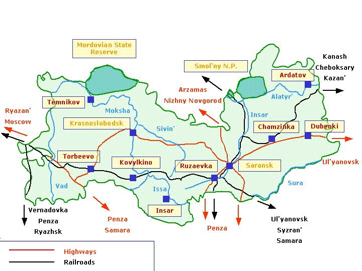
List of largest cities and towns in Mordovia:
Stair chomhaid
Cliceáil ar dáta/am chun an comhad a radharc mar a bhí sé ag an am sin.
| Dáta/Am | Mionsamhail | Toisí | Úsáideoir | Nóta tráchta | |
|---|---|---|---|---|---|
| faoi láthair | 20:38, 22 Bealtaine 2012 | | 810 × 516 (39 KB) | PANONIAN | improved version |
| 16:08, 29 Nollaig 2006 |  | 780 × 478 (20 KB) | Electionworld | {{ew|en|PANONIAN}} Map made by PANONIAN {{PD-user|PANONIAN}} Category:Maps of the Russian republics |
Úsáid comhaid
Tá nasc chuig an gcomhad seo ar na leathanaigh seo a leanas:
Global file usage
The following other wikis use this file:
- Úsáid ar ace.wikipedia.org
- Úsáid ar ba.wikipedia.org
- Úsáid ar be.wikipedia.org
- Úsáid ar bg.wikipedia.org
- Úsáid ar bs.wikipedia.org
- Úsáid ar bxr.wikipedia.org
- Úsáid ar cs.wikipedia.org
- Úsáid ar cv.wikipedia.org
- Úsáid ar da.wikipedia.org
- Úsáid ar de.wikipedia.org
- Úsáid ar en.wikipedia.org
- Úsáid ar fa.wikipedia.org
- Úsáid ar frr.wikipedia.org
- Úsáid ar fr.wikipedia.org
- Úsáid ar id.wikipedia.org
- Úsáid ar it.wikipedia.org
- Úsáid ar ja.wikipedia.org
- Úsáid ar ka.wikipedia.org
- Úsáid ar koi.wikipedia.org
- Úsáid ar ko.wikipedia.org
- Úsáid ar la.wikipedia.org
- Úsáid ar lt.wikipedia.org
- Úsáid ar mhr.wikipedia.org
- Úsáid ar mk.wikipedia.org
- Úsáid ar mn.wikipedia.org
- Úsáid ar mr.wikipedia.org
- Úsáid ar ms.wikipedia.org
- Úsáid ar myv.wikipedia.org
- Úsáid ar nl.wikipedia.org
- Úsáid ar nn.wikipedia.org
- Úsáid ar no.wikipedia.org
- Úsáid ar pl.wikipedia.org
- Úsáid ar pnb.wikipedia.org
- Úsáid ar pt.wikipedia.org
- Úsáid ar ro.wikipedia.org
- Úsáid ar rw.wikipedia.org
- Úsáid ar sah.wikipedia.org
- Úsáid ar sco.wikipedia.org
- Úsáid ar sh.wikipedia.org
- Úsáid ar sk.wikipedia.org
- Úsáid ar sq.wikipedia.org
- Úsáid ar sr.wikipedia.org
- Úsáid ar su.wikipedia.org
- Úsáid ar sv.wikipedia.org
- Úsáid ar ta.wikipedia.org
- Úsáid ar tr.wikipedia.org
- Úsáid ar udm.wikipedia.org
- Úsáid ar ug.wikipedia.org
- Úsáid ar uk.wikipedia.org
View more global usage of this file.