Íomhá:MountMelbourneMap.jpg

Size of this preview: 750 × 600 picteilín. Other resolutions: 300 × 240 picteilín | 600 × 480 picteilín | 1,000 × 800 picteilín.
Taispeáin leagan ardtaifigh den íomhá (1,000 × 800 picteilín, méid comhaid: 216 KB, cineál MIME: image/jpeg)
| Seo comhad as An Cómhaoin Viciméid. Tá an tuairisc as an leathanach tuairisc Cómhaoin a leanas thíos.
|
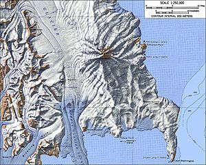
Topographic map of Mount Melbourne (1:250,000 scale).
Source: http://usarc.usgs.gov/antarctic_atlas/ USGS Atlas of Antarctic Research
This image is in the public domain in the United States because it only contains materials that originally came from the United States Geological Survey, an agency of the United States Department of the Interior. For more information, see the official USGS copyright policy.
|
derivative works
Derivative works of this file: Baker Rocks.jpg
Stair chomhaid
Cliceáil ar dáta/am chun an comhad a radharc mar a bhí sé ag an am sin.
| Dáta/Am | Mionsamhail | Toisí | Úsáideoir | Nóta tráchta | |
|---|---|---|---|---|---|
| faoi láthair | 00:59, 15 Eanáir 2005 | | 1,000 × 800 (216 KB) | GarciaB~commonswiki | Topographic map of Mount Melbourne (1:250,000 scale). |
Úsáid comhaid
Tá nasc chuig an gcomhad seo ar na leathanaigh seo a leanas:
Global file usage
The following other wikis use this file:
- Úsáid ar ceb.wikipedia.org
- Úsáid ar de.wikipedia.org
- Úsáid ar en.wikipedia.org
- Úsáid ar es.wikipedia.org
- Úsáid ar fr.wikipedia.org
- Úsáid ar he.wikipedia.org
- Úsáid ar it.wikipedia.org
- Úsáid ar ja.wikipedia.org
- Úsáid ar lv.wikipedia.org
- Úsáid ar mk.wikipedia.org
- Úsáid ar nn.wikipedia.org
- Úsáid ar no.wikipedia.org
- Úsáid ar pl.wikipedia.org
- Úsáid ar uk.wikipedia.org
- Úsáid ar www.wikidata.org
- Úsáid ar zh.wikipedia.org