Íomhá:Palouse hills northeast of Walla Walla.jpg

Size of this preview: 800 × 451 picteilín. Other resolutions: 320 × 180 picteilín | 640 × 361 picteilín | 1,118 × 630 picteilín.
Taispeáin leagan ardtaifigh den íomhá (1,118 × 630 picteilín, méid comhaid: 589 KB, cineál MIME: image/jpeg)
| Seo comhad as An Cómhaoin Viciméid. Tá an tuairisc as an leathanach tuairisc Cómhaoin a leanas thíos.
|
| Tuairisc |
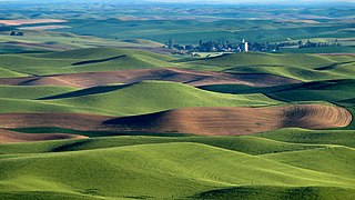
We were hearing a sound like a plane and couldn't figure out where the plane was. Finally one of us spotted a yellow plane flying in the area of the grain elevator! Amazing. Steptoe Butte is the perfect high point in the Palouse Hills to catch the shadow and light play on the hills of the area at sunset and sunrise. This is a morning capture. During one of the ice ages (about 15,000 years ago) Clark Fork River (Montana) was dammed by ice, forming Missoula Lake, the top of which was about 2,000 feet in elevation. About every 2 to 60 years there was thermal erosion of the ice dam and it would collapse and let a flood go through for about 3 days -- whatever time it took to drain Missoula Lake. Many layers of silt left by multiple Missoula floods were topped by loess (dirt blown on top) which made for great rolling hills of farmlands. |
| Dáta | |
| Foinse | Hills, grain elevator, and little yellow plane (really) |
| Údar | Lynn Suckow from Walla Walla, WA, USA |
Ceadúnú
This file is licensed under the Creative Commons Attribution-Share Alike 2.0 Generic license.
- Is féidir:
- an saothar seo a roinnt – an saothar seo a chóipeáil, a dháil amach, agus a tharchur
- an saothar seo a athmheascadh – an saothar seo a oiriúnú
- Ach amháin má leantar na coinníollacha seo a leanas:
- sannadh – Ní mor creidiúint a thabhairt leis an saothar, faoi mar a shonraigh an údar nó tabharthóir an ceadúnais (ach ná húsáid modh a thugann le fios go thacaíonn sé/sí tú féin nó an úsáid a bhaineann tú as an saothar).
- comhroinn araon – Má athraíonn tú nó síneann tú amach an saothar seo, ní féidir é a dháileadh ach amhaín faoin gceadúnas céanna nó ceann cosúil leis an gceann seo.
| Rinne File Upload Bot (Magnus Manske), atá ina riarthóir nó (h)úsáideoir iontaofa, athbhreithniú ar January 13, 2009 ar an íomhá seo, a bunúaslódáilíodh ar Flickr. Tá an t-úsáideoir sin in ann deimhniú go raibh an íomhá sin ar fáil ar Flickr faoin gceadúnas thuas ar an dáta sin. |
Stair chomhaid
Cliceáil ar dáta/am chun an comhad a radharc mar a bhí sé ag an am sin.
| Dáta/Am | Mionsamhail | Toisí | Úsáideoir | Nóta tráchta | |
|---|---|---|---|---|---|
| faoi láthair | 15:03, 13 Eanáir 2009 | | 1,118 × 630 (589 KB) | File Upload Bot (Magnus Manske) | {{Information |Description= We were hearing a sound like a plane and couldn't figure out where the plane was. Finally one of us spotted a yellow plane flying in the area of the grain elevator! Amazing. Steptoe Butte is the perfect high point in the Pa |
Úsáid comhaid
Tá nasc chuig an gcomhad seo ar na leathanaigh seo a leanas:
Global file usage
The following other wikis use this file:
- Úsáid ar ar.wikipedia.org
- Úsáid ar de.wikipedia.org
- Úsáid ar en.wikipedia.org
- Úsáid ar en.wikivoyage.org
- Úsáid ar es.wikipedia.org
- Úsáid ar hsb.wikipedia.org
- Úsáid ar it.wikipedia.org
- Úsáid ar it.wikibooks.org
- Úsáid ar it.wikiversity.org
- Úsáid ar ja.wikipedia.org
- Úsáid ar nl.wikipedia.org
- Úsáid ar ru.wikipedia.org
- Úsáid ar simple.wikipedia.org
- Úsáid ar tr.wikipedia.org
- Úsáid ar uk.wikipedia.org
- Úsáid ar vi.wikipedia.org