Íomhá:Qatar carte.png
Size of this preview: 273 × 599 picteilín. Other resolutions: 109 × 240 picteilín | 322 × 707 picteilín.
Taispeáin leagan ardtaifigh den íomhá (322 × 707 picteilín, méid comhaid: 18 KB, cineál MIME: image/png)
| Seo comhad as An Cómhaoin Viciméid. Tá an tuairisc as an leathanach tuairisc Cómhaoin a leanas thíos.
|
Achoimriú
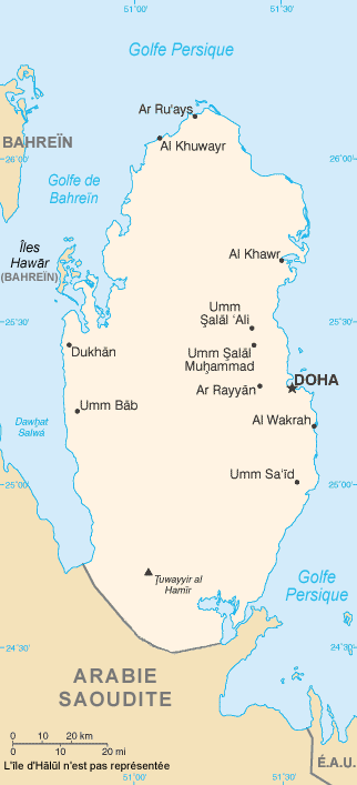
| Tuairisc | Map in French of Qatar |
| Dáta | translation : August 2006 |
| Foinse | CIA World Factbook |
| Údar | of the translation : Eric Gaba (Sting) |
| Ceadúnas (Athúsáid a bhaint as an gcomhad seo) |
PD |
| Leaganacha eile | original English version : Image:Qa-map.PNG |
Français : * Sujet : Carte en français du Qatar ;
- Source : CIA World Factbook ;
- Autre version disponible : anglophone : Image:Qa-map.PNG
- Auteur de la traduction : Eric Gaba (fr:Sting) ;
- Date : Août 2006.
Ceadúnú
This image is in the public domain because it contains materials that originally came from the United States Central Intelligence Agency's World Factbook.
|
 |
| This work was previously under Public Domain, or a Free License. It has been digitally enhanced and/or modified. This derivative work has been (or is hereby) released into the public domain by its author, Sting at the French Wikipedia project. This applies worldwide. In some countries this is not legally possible; if so:
|
Stair chomhaid
Cliceáil ar dáta/am chun an comhad a radharc mar a bhí sé ag an am sin.
| Dáta/Am | Mionsamhail | Toisí | Úsáideoir | Nóta tráchta | |
|---|---|---|---|---|---|
| faoi láthair | 20:07, 31 Bealtaine 2022 | | 322 × 707 (18 KB) | Lojwe | Cropped 2 % horizontally, 1 % vertically using CropTool with precise mode. |
| 03:17, 30 Meán Fómhair 2019 |  | 327 × 713 (38 KB) | Io Herodotus | border in the south | |
| 15:55, 31 Lúnasa 2006 |  | 327 × 713 (45 KB) | Sting | {{Information |Description=Map in French of Qatar |Source=[https://www.cia.gov/cia/publications/factbook/index.html CIA World Factbook] |Date=translation : August 2006 |Author=of the translation : Eric Gaba (Sting) |Permission=PD |other_ver |
Úsáid comhaid
Níl nasc ó aon leathanach eile don íomhá seo.
Global file usage
The following other wikis use this file:
- Úsáid ar ca.wikipedia.org
- Úsáid ar fr.wikipedia.org
- Úsáid ar mg.wikipedia.org
- Úsáid ar pcd.wikipedia.org
- Úsáid ar pt.wikipedia.org