Íomhá:Saxony locator map (1000).svg

Size of this PNG preview of this SVG file: 686 × 600 picteilín. Other resolutions: 275 × 240 picteilín | 549 × 480 picteilín | 878 × 768 picteilín | 1,171 × 1,024 picteilín | 2,342 × 2,048 picteilín | 4,431 × 3,875 picteilín.
Taispeáin leagan ardtaifigh den íomhá (Comhad SVG, ainmniúil 4,431 × 3,875 picteilíni, méid comhaid: 4.7 MB)
| Seo comhad as An Cómhaoin Viciméid. Tá an tuairisc as an leathanach tuairisc Cómhaoin a leanas thíos.
|
Achoimriú
This W3C-unspecified vector image was created with Inkscape .
| Tuairisc |
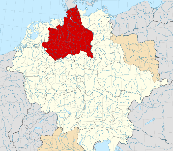
English: A map of the Duchy of Saxony (German: Herzogtum Sachsen) around 1000 CE.
The map is derived from a vectorised version of one found in Professor G. Droysens Allgemeiner Historischer Handatlas, which was published in 1886 by R. Andrée Plate, and is now in the public domain. Note that while it uses the same scheme as standard location/locator maps, this map technically does not conform to the standard, as it is not in equirectangular projection. Therefore grid lines for latitude and longitude are also included on the sub-map. |
| Dáta | |
| Foinse |
File: own work Data: File:Droysens-22-23.jpg |
| Údar | Alphathon /ˈæɫfə.θɒn/ (talk) |
| Leaganacha eile |
|
.svg)
.svg)
.svg)
.svg)

.svg)
.svg)
.svg)
Ceadúnú
This file is licensed under the Creative Commons Attribution-Share Alike 4.0 International license.
- Is féidir:
- an saothar seo a roinnt – an saothar seo a chóipeáil, a dháil amach, agus a tharchur
- an saothar seo a athmheascadh – an saothar seo a oiriúnú
- Ach amháin má leantar na coinníollacha seo a leanas:
- sannadh – Ní mor creidiúint a thabhairt leis an saothar, faoi mar a shonraigh an údar nó tabharthóir an ceadúnais (ach ná húsáid modh a thugann le fios go thacaíonn sé/sí tú féin nó an úsáid a bhaineann tú as an saothar).
- comhroinn araon – Má athraíonn tú nó síneann tú amach an saothar seo, ní féidir é a dháileadh ach amhaín faoin gceadúnas céanna nó ceann cosúil leis an gceann seo.
Stair chomhaid
Cliceáil ar dáta/am chun an comhad a radharc mar a bhí sé ag an am sin.
| Dáta/Am | Mionsamhail | Toisí | Úsáideoir | Nóta tráchta | |
|---|---|---|---|---|---|
| faoi láthair | 16:15, 22 Bealtaine 2016 | | 4,431 × 3,875 (4.7 MB) | Alphathon | Changed colour of the Kingdom of Italy to reflect its inclusion in the Holy Roman Empire. Changed the colour of Silesian tributaries so as the not imply it was part of the Kingdom. Also changed colour of Rügen since it was neither in the Empire nor th... |
| 02:26, 18 Bealtaine 2016 |  | 4,431 × 3,875 (4.7 MB) | Alphathon | == {{int:filedesc}} == {{Inkscape}} {{Information |Description={{en|A map of the en:Duchy of Saxony (German: ''Herzogtum Sachsen'') around 1000 CE. The map is derived from a vectorised version of one found in Professor G. Droysens Allgem... |
Úsáid comhaid
Tá nasc chuig an gcomhad seo ar na leathanaigh seo a leanas:
Global file usage
The following other wikis use this file:
- Úsáid ar ar.wikipedia.org
- Úsáid ar ast.wikipedia.org
- Úsáid ar azb.wikipedia.org
- Úsáid ar be.wikipedia.org
- Úsáid ar bg.wikipedia.org
- Úsáid ar ca.wikipedia.org
- Úsáid ar cs.wikipedia.org
- Úsáid ar de.wikipedia.org
- Úsáid ar el.wikipedia.org
- Úsáid ar en.wikipedia.org
- Úsáid ar es.wikipedia.org
- Úsáid ar et.wikipedia.org
- Úsáid ar fa.wikipedia.org
- Úsáid ar fr.wikipedia.org
- Úsáid ar fy.wikipedia.org
- Úsáid ar it.wikipedia.org
- Úsáid ar ja.wikipedia.org
- Úsáid ar ko.wikipedia.org
- Úsáid ar mk.wikipedia.org
- Úsáid ar pl.wikipedia.org
- Úsáid ar pl.wiktionary.org
- Úsáid ar th.wikipedia.org
- Úsáid ar tr.wikipedia.org
- Úsáid ar vi.wikipedia.org
- Úsáid ar www.wikidata.org
- Úsáid ar zh.wikipedia.org
.svg)