Íomhá:Sulawesi map.PNG

Size of this preview: 543 × 599 picteilín. Other resolutions: 217 × 240 picteilín | 435 × 480 picteilín | 696 × 768 picteilín | 928 × 1,024 picteilín | 1,492 × 1,647 picteilín.
Taispeáin leagan ardtaifigh den íomhá (1,492 × 1,647 picteilín, méid comhaid: 83 KB, cineál MIME: image/png)
| Seo comhad as An Cómhaoin Viciméid. Tá an tuairisc as an leathanach tuairisc Cómhaoin a leanas thíos.
|
Achoimriú
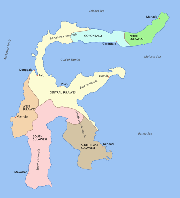
Sulawesi showing provinces, their capital cities, a few other cities and some surrounding areas of water. Note that there are other islands in this area which are not shown as this is a map of Sulawesi island itself.
For a blank map see Image:Sulawesi blank.PNG
derivative works
Derivative works of this file: Sulawesi map id.png
Ceadúnú

|
Tugtar cead an doiciméad seo a chóipeáil, a dháileadh agus/nó a mhodhnú faoi théarmaí an Ceadúnas Doiciméadúcháin Saor ó GNU, Leagan 1.2 nó aon leagan níos déanaí a d’fhoilsigh an Fondúireacht Bogearraí Saor in Aisce; gan aon Rannóga Inmheánacha, gan aon Téacsanna Clúdaigh Tosaigh, agus gan aon Téacsanna Clúdaigh Cúil. Tá cóip den cheadúnas san áireamh sa chuid dar teideal Ceadúnas Doiciméadúcháin Saor ó GNU. |
| This file is licensed under the Creative Commons Attribution-Share Alike 3.0 Unported license. | ||
| ||
| This licensing tag was added to this file as part of the GFDL licensing update. |
Stair chomhaid
Cliceáil ar dáta/am chun an comhad a radharc mar a bhí sé ag an am sin.
| Dáta/Am | Mionsamhail | Toisí | Úsáideoir | Nóta tráchta | |
|---|---|---|---|---|---|
| faoi láthair | 12:11, 11 Márta 2006 | | 1,492 × 1,647 (83 KB) | Roke~commonswiki | fixed borders of provinces |
| 04:55, 11 Márta 2006 |  | 1,492 × 1,647 (82 KB) | Roke~commonswiki | Sulawesi showing provinces, their capital cities, a few other cities and some surrounding areas of water. Note that there are other islands in this area which are not shown as this is a map of Sulawesi island itself. Category:Sulawesi [[Category:Maps |
Úsáid comhaid
Tá nasc chuig an gcomhad seo ar na leathanaigh seo a leanas:
Global file usage
The following other wikis use this file:
- Úsáid ar af.wikipedia.org
- Úsáid ar bg.wikipedia.org
- Úsáid ar bn.wikipedia.org
- Úsáid ar bug.wikipedia.org
- Úsáid ar ca.wikipedia.org
- Úsáid ar ceb.wikipedia.org
- Úsáid ar cs.wikipedia.org
- Úsáid ar cy.wikipedia.org
- Úsáid ar el.wikipedia.org
- Úsáid ar en.wikipedia.org
- Úsáid ar es.wikipedia.org
- Úsáid ar eu.wikipedia.org
- Úsáid ar fa.wikipedia.org
- Úsáid ar fi.wikipedia.org
- Úsáid ar fr.wikipedia.org
- Úsáid ar gl.wikipedia.org
- Úsáid ar gl.wiktionary.org
- Úsáid ar hi.wikipedia.org
- Úsáid ar hu.wikipedia.org
- Úsáid ar id.wiktionary.org
- Úsáid ar ilo.wikipedia.org
- Úsáid ar is.wikipedia.org
- Úsáid ar it.wikipedia.org
- Úsáid ar ja.wikipedia.org
- Úsáid ar kk.wikipedia.org
- Úsáid ar km.wikipedia.org
- Úsáid ar la.wikipedia.org
- Úsáid ar map-bms.wikipedia.org
- Úsáid ar mi.wikipedia.org
- Úsáid ar ml.wikipedia.org
- Úsáid ar mrj.wikipedia.org
- Úsáid ar mr.wikipedia.org
View more global usage of this file.