Íomhá:Vanuatu Provinces.JPG
Size of this preview: 549 × 599 picteilín. Other resolutions: 220 × 240 picteilín | 558 × 609 picteilín.
Taispeáin leagan ardtaifigh den íomhá (558 × 609 picteilín, méid comhaid: 36 KB, cineál MIME: image/jpeg)
| Seo comhad as An Cómhaoin Viciméid. Tá an tuairisc as an leathanach tuairisc Cómhaoin a leanas thíos.
|
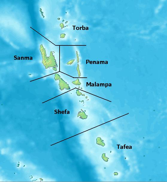
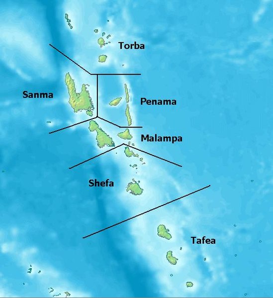
Map of Provinces of Vanuatu. Created with DEMIS World Map Server[dead link]
License: http://www2.demis.nl/mapserver/DataSrc.htm archive copy at the Wayback Machine
| This work has been released into the public domain by its author, DEMIS BV. This applies worldwide. In some countries this may not be legally possible; if so: DEMIS BV grants anyone the right to use this work for any purpose, without any conditions, unless such conditions are required by law.
|
Stair chomhaid
Cliceáil ar dáta/am chun an comhad a radharc mar a bhí sé ag an am sin.
| Dáta/Am | Mionsamhail | Toisí | Úsáideoir | Nóta tráchta | |
|---|---|---|---|---|---|
| faoi láthair | 00:10, 25 Iúil 2005 | | 558 × 609 (36 KB) | Taichi | Map of Provinces of Vanuatu. Created with [ http://www2.demis.nl/mapserver/mapper.asp DEMIS World Map Server] License: http://www2.demis.nl/mapserver/DataSrc.htm {{PD}} Category:Maps |
Úsáid comhaid
Níl nasc ó aon leathanach eile don íomhá seo.
Global file usage
The following other wikis use this file:
- Úsáid ar als.wikipedia.org
- Úsáid ar arz.wikipedia.org
- Úsáid ar az.wikipedia.org
- Úsáid ar bi.wikipedia.org
- Úsáid ar bjn.wikipedia.org
- Úsáid ar ceb.wikipedia.org
- Úsáid ar cs.wikipedia.org
- Úsáid ar da.wikipedia.org
- Úsáid ar de.wikipedia.org
- Úsáid ar el.wikipedia.org
- Úsáid ar en.wikipedia.org
- Úsáid ar eo.wikipedia.org
- Úsáid ar es.wikipedia.org
- Úsáid ar et.wikipedia.org
- Úsáid ar eu.wikipedia.org
- Úsáid ar fi.wikipedia.org
- Úsáid ar fi.wiktionary.org
- Úsáid ar frr.wikipedia.org
- Úsáid ar fr.wikipedia.org
- Úsáid ar fr.wiktionary.org
- Úsáid ar gl.wikipedia.org
- Úsáid ar hi.wikipedia.org
- Úsáid ar hr.wikipedia.org
View more global usage of this file.