Íomhá:Charlestonriversmap.png

Size of this preview: 600 × 600 picteilín. Other resolutions: 240 × 240 picteilín | 480 × 480 picteilín | 1,000 × 1,000 picteilín.
Taispeáin leagan ardtaifigh den íomhá (1,000 × 1,000 picteilín, méid comhaid: 395 KB, cineál MIME: image/png)
| Seo comhad as An Cómhaoin Viciméid. Tá an tuairisc as an leathanach tuairisc Cómhaoin a leanas thíos.
|
Achoimriú
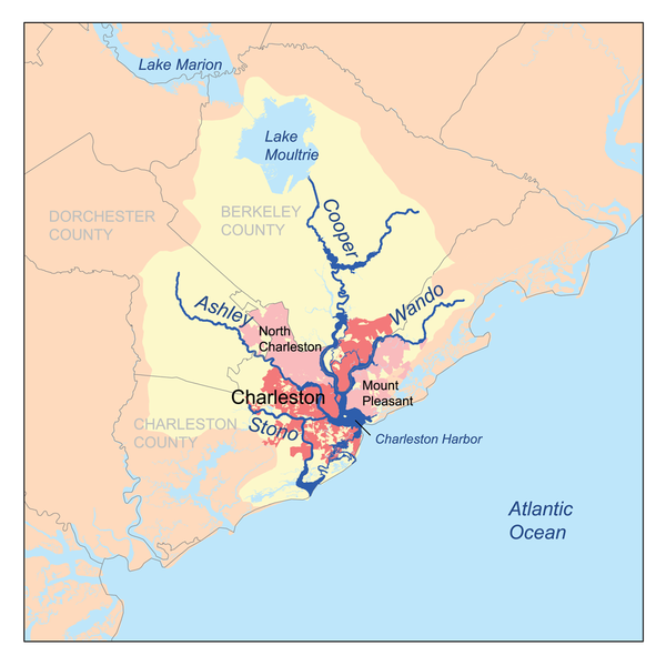
| Tuairisc | This is a map of the Charleston Harbor watershed, including the Ashley, Cooper, Wando and Stono rivers. I, Karl Musser, created it based on USGS and Census Bureau data. |
| Dáta | 1ú Márta 2007 (original upload date) |
| Foinse | No machine-readable source provided. Own work assumed (based on copyright claims). |
| Údar | No machine-readable author provided. Kmusser assumed (based on copyright claims). |
| Leaganacha eile |
.png)
Ceadúnú
Is mise sealbhóir cóipchirt an shaothair seo agus foilsím é faoin gceadúnas seo a leanas:
This file is licensed under the Creative Commons Attribution-Share Alike 2.5 Generic license.
- Is féidir:
- an saothar seo a roinnt – an saothar seo a chóipeáil, a dháil amach, agus a tharchur
- an saothar seo a athmheascadh – an saothar seo a oiriúnú
- Ach amháin má leantar na coinníollacha seo a leanas:
- sannadh – Ní mor creidiúint a thabhairt leis an saothar, faoi mar a shonraigh an údar nó tabharthóir an ceadúnais (ach ná húsáid modh a thugann le fios go thacaíonn sé/sí tú féin nó an úsáid a bhaineann tú as an saothar).
- comhroinn araon – Má athraíonn tú nó síneann tú amach an saothar seo, ní féidir é a dháileadh ach amhaín faoin gceadúnas céanna nó ceann cosúil leis an gceann seo.
Stair chomhaid
Cliceáil ar dáta/am chun an comhad a radharc mar a bhí sé ag an am sin.
| Dáta/Am | Mionsamhail | Toisí | Úsáideoir | Nóta tráchta | |
|---|---|---|---|---|---|
| faoi láthair | 18:45, 1 Márta 2007 | | 1,000 × 1,000 (395 KB) | Kmusser | This is a map of the Charleston Harbor watershed, including the Ashley, Cooper, Wando and Stono rivers. I, [[:en |
Úsáid comhaid
Níl nasc ó aon leathanach eile don íomhá seo.
Global file usage
The following other wikis use this file:
- Úsáid ar bg.wikipedia.org
- Úsáid ar en.wikipedia.org
- Úsáid ar eo.wikipedia.org
- Úsáid ar es.wikipedia.org
- Úsáid ar et.wikipedia.org
- Úsáid ar fa.wikipedia.org
- Úsáid ar fo.wikipedia.org
- Úsáid ar fr.wikipedia.org
- Úsáid ar gl.wikipedia.org
- Úsáid ar he.wikipedia.org
- Úsáid ar id.wikipedia.org
- Úsáid ar it.wikipedia.org
- Úsáid ar ja.wikipedia.org
- Úsáid ar lt.wikipedia.org
- Úsáid ar sv.wikipedia.org
- Úsáid ar www.wikidata.org