Íomhá:Crittenden County Arkansas Incorporated and Unincorporated areas West Memphis Highlighted.svg

Size of this PNG preview of this SVG file: 800 × 600 picteilín. Other resolutions: 320 × 240 picteilín | 640 × 480 picteilín | 1,024 × 768 picteilín | 1,280 × 960 picteilín | 2,560 × 1,920 picteilín.
Taispeáin leagan ardtaifigh den íomhá (Comhad SVG, ainmniúil 800 × 600 picteilíni, méid comhaid: 103 KB)
| Seo comhad as An Cómhaoin Viciméid. Tá an tuairisc as an leathanach tuairisc Cómhaoin a leanas thíos.
|
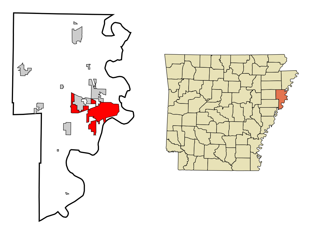
| Tuairisc | This map shows the incorporated and unincorporated areas in Crittenden County, Arkansas, highlighting West_Memphis in red. It was created with a custom script with US Census Bureau data and modified with Inkscape. |
| Dáta | |
| Foinse | My own work, based on public domain information. Based on similar map concepts by Ixnayonthetimmay |
| Údar | Arkyan |
| Ceadúnas (Athúsáid a bhaint as an gcomhad seo) |
Own work, copyleft: Multi-license with GFDL and Creative Commons CC-BY-SA-2.5 and older versions (2.0 and 1.0) |
Is mise sealbhóir cóipchirt an shaothair seo agus foilsím é faoi na ceadúnais seo a leanas:

|
Tugtar cead an doiciméad seo a chóipeáil, a dháileadh agus/nó a mhodhnú faoi théarmaí an Ceadúnas Doiciméadúcháin Saor ó GNU, Leagan 1.2 nó aon leagan níos déanaí a d’fhoilsigh an Fondúireacht Bogearraí Saor in Aisce; gan aon Rannóga Inmheánacha, gan aon Téacsanna Clúdaigh Tosaigh, agus gan aon Téacsanna Clúdaigh Cúil. Tá cóip den cheadúnas san áireamh sa chuid dar teideal Ceadúnas Doiciméadúcháin Saor ó GNU. |
| This file is licensed under the Creative Commons Attribution-Share Alike 3.0 Unported license. | ||
| ||
| This licensing tag was added to this file as part of the GFDL licensing update. |
This file is licensed under the Creative Commons Attribution-Share Alike 2.5 Generic, 2.0 Generic and 1.0 Generic license.
- Is féidir:
- an saothar seo a roinnt – an saothar seo a chóipeáil, a dháil amach, agus a tharchur
- an saothar seo a athmheascadh – an saothar seo a oiriúnú
- Ach amháin má leantar na coinníollacha seo a leanas:
- sannadh – Ní mor creidiúint a thabhairt leis an saothar, faoi mar a shonraigh an údar nó tabharthóir an ceadúnais (ach ná húsáid modh a thugann le fios go thacaíonn sé/sí tú féin nó an úsáid a bhaineann tú as an saothar).
- comhroinn araon – Má athraíonn tú nó síneann tú amach an saothar seo, ní féidir é a dháileadh ach amhaín faoin gceadúnas céanna nó ceann cosúil leis an gceann seo.
Is féidir leat a roghnú an ceadúnas do rogha
Stair chomhaid
Cliceáil ar dáta/am chun an comhad a radharc mar a bhí sé ag an am sin.
| Dáta/Am | Mionsamhail | Toisí | Úsáideoir | Nóta tráchta | |
|---|---|---|---|---|---|
| faoi láthair | 19:03, 19 Meitheamh 2007 | | 800 × 600 (103 KB) | Shereth | {{Information |Description=This map shows the incorporated and unincorporated areas in Crittenden County, Arkansas, highlighting West_Memphis in red. |
Úsáid comhaid
Tá nasc chuig an gcomhad seo ar na leathanaigh seo a leanas:
Global file usage
The following other wikis use this file:
- Úsáid ar ar.wikipedia.org
- Úsáid ar ca.wikipedia.org
- Úsáid ar ceb.wikipedia.org
- Úsáid ar cy.wikipedia.org
- Úsáid ar de.wikipedia.org
- Úsáid ar eo.wikipedia.org
- Úsáid ar eu.wikipedia.org
- Úsáid ar fa.wikipedia.org
- Úsáid ar fr.wikipedia.org
- Úsáid ar ht.wikipedia.org
- Úsáid ar it.wikipedia.org
- Úsáid ar sh.wikipedia.org
- Úsáid ar sr.wikipedia.org
- Úsáid ar tt.wikipedia.org
- Úsáid ar ur.wikipedia.org
- Úsáid ar vo.wikipedia.org
- Úsáid ar www.wikidata.org
- Úsáid ar zh-min-nan.wikipedia.org