Íomhá:Dal gCais Tribal Map.png

Size of this preview: 800 × 477 picteilín. Other resolutions: 320 × 191 picteilín | 640 × 381 picteilín | 1,024 × 610 picteilín | 1,280 × 763 picteilín | 2,560 × 1,525 picteilín | 3,733 × 2,224 picteilín.
Taispeáin leagan ardtaifigh den íomhá (3,733 × 2,224 picteilín, méid comhaid: 3.68 MB, cineál MIME: image/png)
| Seo comhad as An Cómhaoin Viciméid. Tá an tuairisc as an leathanach tuairisc Cómhaoin a leanas thíos.
|
Achoimriú
| Tuairisc |
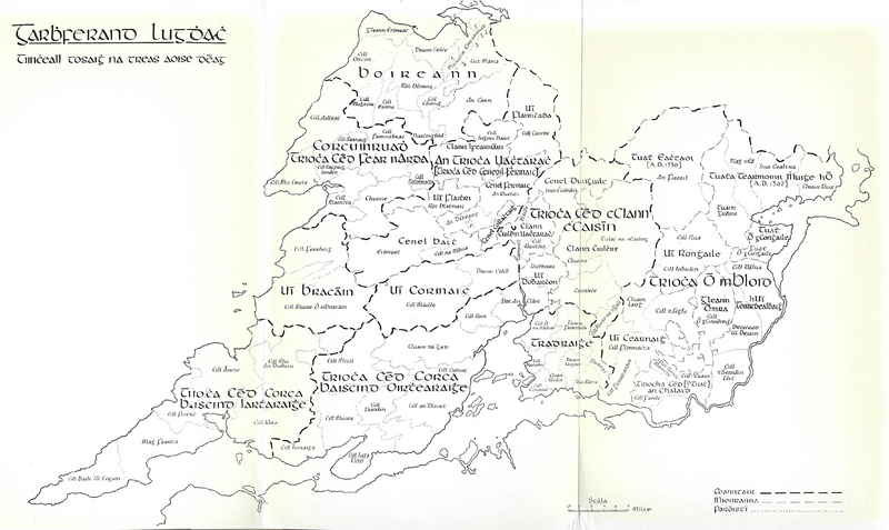
English: Clare Tribal Map 1200AD |
| Dáta | |
| Foinse | Conntae an Chláir a Trioća Agus and a Tuata |
| Údar | Seán Ó hÓgáin |
Ceadúnú
This file is licensed under the Creative Commons Attribution-Share Alike 4.0 International license.
- Is féidir:
- an saothar seo a roinnt – an saothar seo a chóipeáil, a dháil amach, agus a tharchur
- an saothar seo a athmheascadh – an saothar seo a oiriúnú
- Ach amháin má leantar na coinníollacha seo a leanas:
- sannadh – Ní mor creidiúint a thabhairt leis an saothar, faoi mar a shonraigh an údar nó tabharthóir an ceadúnais (ach ná húsáid modh a thugann le fios go thacaíonn sé/sí tú féin nó an úsáid a bhaineann tú as an saothar).
- comhroinn araon – Má athraíonn tú nó síneann tú amach an saothar seo, ní féidir é a dháileadh ach amhaín faoin gceadúnas céanna nó ceann cosúil leis an gceann seo.
Stair chomhaid
Cliceáil ar dáta/am chun an comhad a radharc mar a bhí sé ag an am sin.
| Dáta/Am | Mionsamhail | Toisí | Úsáideoir | Nóta tráchta | |
|---|---|---|---|---|---|
| faoi láthair | 19:23, 7 Meán Fómhair 2021 | | 3,733 × 2,224 (3.68 MB) | SKIBLY101 | full |
| 06:57, 26 Lúnasa 2021 |  | 1,013 × 705 (885 KB) | SKIBLY101 | Uploaded a work by John O'Donovan and Eugene O'Curry from James Frost - History and Topography of Clare OR Ordnance Survey letters from Clare by Eugene O'Curry with UploadWizard |
Úsáid comhaid
Tá nasc chuig an gcomhad seo ar na leathanaigh seo a leanas:
Global file usage
The following other wikis use this file:
- Úsáid ar en.wikipedia.org