Íomhá:Dromaius novaehollandiae map distribution 2.svg

Size of this PNG preview of this SVG file: 736 × 600 picteilín. Other resolutions: 295 × 240 picteilín | 589 × 480 picteilín | 942 × 768 picteilín | 1,257 × 1,024 picteilín | 2,513 × 2,048 picteilín | 1,108 × 903 picteilín.
Taispeáin leagan ardtaifigh den íomhá (Comhad SVG, ainmniúil 1,108 × 903 picteilíni, méid comhaid: 114 KB)
| Seo comhad as An Cómhaoin Viciméid. Tá an tuairisc as an leathanach tuairisc Cómhaoin a leanas thíos.
|
Achoimriú
| Tuairisc |
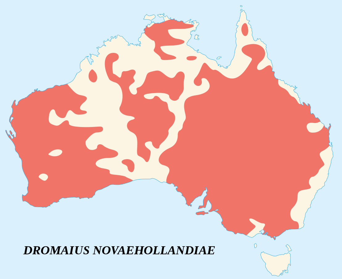
English: Emu's recorded observations map (Dromaius Novaehollandiae).
Areas where emu has been recorded. Français : Carte d'observations de l'Émeu d'Australie (Dromaius Novaehollandiae).
Zones où des émeus ont été observés. |
||
| Dáta | |||
| Foinse |
English:
Français : |
||
| Údar | Sémhur (talk) | ||
| Creidiúint (required by the license) | © Sémhur / Wikimedia Commons / | ||
| SVG | W3C-validity not checked.
|
||
| Atelier graphique |

| Camera location | | View this and other nearby images on: OpenStreetMap |
|---|
Ceadúnú
Is mise sealbhóir cóipchirt an shaothair seo agus foilsím é faoi na ceadúnais seo a leanas:
| Copyleft: This work of art is free; you can redistribute it and/or modify it according to terms of the Free Art License. You will find a specimen of this license on the Copyleft Attitude site as well as on other sites. |
This file is licensed under the Creative Commons Attribution-Share Alike 4.0 International, 3.0 Unported, 2.5 Generic, 2.0 Generic and 1.0 Generic license.
- Is féidir:
- an saothar seo a roinnt – an saothar seo a chóipeáil, a dháil amach, agus a tharchur
- an saothar seo a athmheascadh – an saothar seo a oiriúnú
- Ach amháin má leantar na coinníollacha seo a leanas:
- sannadh – Ní mor creidiúint a thabhairt leis an saothar, faoi mar a shonraigh an údar nó tabharthóir an ceadúnais (ach ná húsáid modh a thugann le fios go thacaíonn sé/sí tú féin nó an úsáid a bhaineann tú as an saothar).
- comhroinn araon – Má athraíonn tú nó síneann tú amach an saothar seo, ní féidir é a dháileadh ach amhaín faoin gceadúnas céanna nó ceann cosúil leis an gceann seo.
Is féidir leat a roghnú an ceadúnas do rogha
Stair chomhaid
Cliceáil ar dáta/am chun an comhad a radharc mar a bhí sé ag an am sin.
| Dáta/Am | Mionsamhail | Toisí | Úsáideoir | Nóta tráchta | |
|---|---|---|---|---|---|
| faoi láthair | 15:09, 25 Meitheamh 2007 | | 1,108 × 903 (114 KB) | Sémhur | better coast lines |
| 11:29, 24 Meitheamh 2007 |  | 1,108 × 903 (72 KB) | Sémhur | {{Information |Description= {{fr|Carte d'observations de l'émeu (''Dromaius Novaehollandiae'').<br/>Légende : en marron, zones où des émeus ont été observés.}} {{en|Emu's recorded observations map (''Dromaius Novaehollandiae'').<br/>Legend : maroon |
Úsáid comhaid
Tá nasc chuig an gcomhad seo ar 2 an leathanach seo a leanas:
Global file usage
The following other wikis use this file:
- Úsáid ar an.wikipedia.org
- Úsáid ar ar.wikipedia.org
- Úsáid ar arz.wikipedia.org
- Úsáid ar ast.wikipedia.org
- Úsáid ar be.wikipedia.org
- Úsáid ar bg.wikipedia.org
- Úsáid ar bn.wikipedia.org
- Úsáid ar ca.wikipedia.org
- Úsáid ar ceb.wikipedia.org
- Úsáid ar cs.wikipedia.org
- Úsáid ar cy.wikipedia.org
- Úsáid ar de.wikipedia.org
- Úsáid ar en.wikipedia.org
- Úsáid ar eo.wikipedia.org
- Úsáid ar et.wikipedia.org
- Úsáid ar eu.wikipedia.org
- Úsáid ar fa.wikipedia.org
- Úsáid ar fi.wikipedia.org
- Úsáid ar gl.wikipedia.org
- Úsáid ar gu.wikipedia.org
- Úsáid ar he.wikipedia.org
- Úsáid ar hr.wikipedia.org
- Úsáid ar hu.wikipedia.org
- Úsáid ar hy.wikipedia.org
- Úsáid ar id.wikipedia.org
- Úsáid ar incubator.wikimedia.org
- Úsáid ar is.wikipedia.org
- Úsáid ar ja.wikipedia.org
- Úsáid ar jv.wikipedia.org
- Úsáid ar ka.wikipedia.org
- Úsáid ar kk.wikipedia.org
- Úsáid ar kn.wikipedia.org
- Úsáid ar ko.wikipedia.org
- Úsáid ar kw.wikipedia.org
- Úsáid ar la.wikipedia.org
- Úsáid ar lt.wikipedia.org
- Úsáid ar lv.wikipedia.org
- Úsáid ar mk.wikipedia.org
- Úsáid ar ml.wikipedia.org
- Úsáid ar ms.wikipedia.org
- Úsáid ar my.wikipedia.org
- Úsáid ar nn.wikipedia.org
- Úsáid ar no.wikipedia.org
- Úsáid ar nv.wikipedia.org
- Úsáid ar or.wikipedia.org
- Úsáid ar pa.wikipedia.org
- Úsáid ar pl.wikipedia.org
View more global usage of this file.