Íomhá:France map Lambert-93 topographic-ancient Roman roads.svg

Size of this PNG preview of this SVG file: 644 × 600 picteilín. Other resolutions: 258 × 240 picteilín | 515 × 480 picteilín | 825 × 768 picteilín | 1,099 × 1,024 picteilín | 2,199 × 2,048 picteilín | 1,766 × 1,645 picteilín.
Taispeáin leagan ardtaifigh den íomhá (Comhad SVG, ainmniúil 1,766 × 1,645 picteilíni, méid comhaid: 1.6 MB)
| Seo comhad as An Cómhaoin Viciméid. Tá an tuairisc as an leathanach tuairisc Cómhaoin a leanas thíos.
|
Achoimriú
| Tuairisc |
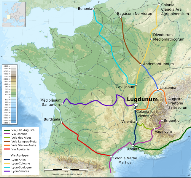
Français : Carte topographique représentant les principales voies romaines construites en Gaule sous l'Empire Romain. |
| Dáta | |
| Foinse | Obair féin from a topographic map from Eric Gaba, and from data provided by www.omnesviae.org |
| Údar | Eric Gaba, Flappiefh |
| Leaganacha eile |
|
Ceadúnú
Is mise sealbhóir cóipchirt an shaothair seo agus foilsím é faoi na ceadúnais seo a leanas:

|
Tugtar cead an doiciméad seo a chóipeáil, a dháileadh agus/nó a mhodhnú faoi théarmaí an Ceadúnas Doiciméadúcháin Saor ó GNU, Leagan 1.2 nó aon leagan níos déanaí a d’fhoilsigh an Fondúireacht Bogearraí Saor in Aisce; gan aon Rannóga Inmheánacha, gan aon Téacsanna Clúdaigh Tosaigh, agus gan aon Téacsanna Clúdaigh Cúil. Tá cóip den cheadúnas san áireamh sa chuid dar teideal Ceadúnas Doiciméadúcháin Saor ó GNU. |
This file is licensed under the Creative Commons Attribution-Share Alike 4.0 International, 3.0 Unported, 2.5 Generic, 2.0 Generic and 1.0 Generic license.
- Is féidir:
- an saothar seo a roinnt – an saothar seo a chóipeáil, a dháil amach, agus a tharchur
- an saothar seo a athmheascadh – an saothar seo a oiriúnú
- Ach amháin má leantar na coinníollacha seo a leanas:
- sannadh – Ní mor creidiúint a thabhairt leis an saothar, faoi mar a shonraigh an údar nó tabharthóir an ceadúnais (ach ná húsáid modh a thugann le fios go thacaíonn sé/sí tú féin nó an úsáid a bhaineann tú as an saothar).
- comhroinn araon – Má athraíonn tú nó síneann tú amach an saothar seo, ní féidir é a dháileadh ach amhaín faoin gceadúnas céanna nó ceann cosúil leis an gceann seo.
Is féidir leat a roghnú an ceadúnas do rogha
Stair chomhaid
Cliceáil ar dáta/am chun an comhad a radharc mar a bhí sé ag an am sin.
| Dáta/Am | Mionsamhail | Toisí | Úsáideoir | Nóta tráchta | |
|---|---|---|---|---|---|
| faoi láthair | 22:18, 6 Nollaig 2013 | | 1,766 × 1,645 (1.6 MB) | Ciaurlec | Correction en légende: Aggripa->Agrippa |
| 11:45, 20 Meán Fómhair 2013 |  | 1,766 × 1,645 (1.6 MB) | Sting | Correction : inversion Andemantunnum (Langres) <=> Cavillonum (Chalon-sur-Saône) | |
| 17:15, 11 Iúil 2012 |  | 1,766 × 1,645 (1.6 MB) | Flappiefh |
Úsáid comhaid
Tá nasc chuig an gcomhad seo ar na leathanaigh seo a leanas:
Global file usage
The following other wikis use this file:
- Úsáid ar ar.wikipedia.org
- Úsáid ar arz.wikipedia.org
- Úsáid ar ca.wikipedia.org
- Úsáid ar cs.wikipedia.org
- Úsáid ar de.wikipedia.org
- Úsáid ar el.wikipedia.org
- Úsáid ar en.wikipedia.org
- Úsáid ar es.wikipedia.org
- Úsáid ar eu.wikipedia.org
- Úsáid ar fr.wikipedia.org
- Lyon pendant l'Antiquité
- Voie romaine
- Histoire de la Drôme
- Voie romaine d'Agrippa
- Puch-d'Agenais
- Via Aurelia
- Histoire de l'Yonne
- Via Aquitania
- Voies romaines en Gaule
- Histoire d'Arles à l'époque romaine
- Histoire de l'Occitanie
- Wikipédia:Atelier graphique/Cartes/Archives/juillet 2012
- Utilisateur:Le plombier du désert/Brouillon
- Histoire de la plomberie
- Voie romaine de Reims à Bavay
- Voie romaine de Reims à Langres
- Voie romaine de Reims à Soissons
- Úsáid ar hu.wikipedia.org
- Úsáid ar it.wikipedia.org
- Úsáid ar ja.wikipedia.org
- Úsáid ar ko.wikipedia.org
- Úsáid ar lb.wikipedia.org
View more global usage of this file.