Íomhá:Geofeatures map of Chubu Japan ja.svg

Size of this PNG preview of this SVG file: 540 × 600 picteilín. Other resolutions: 216 × 240 picteilín | 432 × 480 picteilín | 691 × 768 picteilín | 922 × 1,024 picteilín | 1,843 × 2,048 picteilín | 1,080 × 1,200 picteilín.
Taispeáin leagan ardtaifigh den íomhá (Comhad SVG, ainmniúil 1,080 × 1,200 picteilíni, méid comhaid: 3.98 MB)
| Seo comhad as An Cómhaoin Viciméid. Tá an tuairisc as an leathanach tuairisc Cómhaoin a leanas thíos.
|
Achoimriú
| Tuairisc |
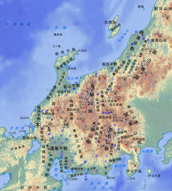
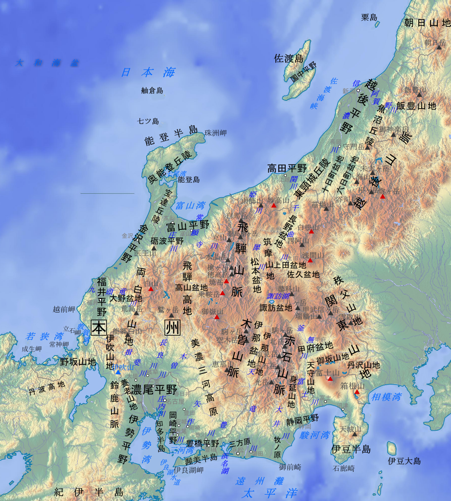
日本語: 中部地方の主要地形名(山地、平野、海域など)を示した地形図。説明:日本語。
各地形の名称と位置は原則として『新版日本国勢地図』(1990年, 国土地理院HP公開版)に準拠。山岳名や河川名、都市名など一部は電子国土基本図(地理院地図)を参照した。
English: Geographical features map of Chubu Region in Japan with Japanese language description. |
| Dáta | |
| Foinse | Original map:maps-for-free.com |
| Údar |
Original map:maps-for-free.com(Hans Braxmeier) |
This W3C-unspecified vector image was created with Inkscape .
Ceadúnú
| This file is made available under the Creative Commons CC0 1.0 Universal Public Domain Dedication. | |
| The person who associated a work with this deed has dedicated the work to the public domain by waiving all of their rights to the work worldwide under copyright law, including all related and neighboring rights, to the extent allowed by law. You can copy, modify, distribute and perform the work, even for commercial purposes, all without asking permission.
|
Stair chomhaid
Cliceáil ar dáta/am chun an comhad a radharc mar a bhí sé ag an am sin.
| Dáta/Am | Mionsamhail | Toisí | Úsáideoir | Nóta tráchta | |
|---|---|---|---|---|---|
| faoi láthair | 09:54, 29 Nollaig 2018 | | 1,080 × 1,200 (3.98 MB) | Peka | 誤字訂正:「東頸城丘陵」の頸を頚から訂正、「筑摩山地」の表示位置を南にずらす。ノートも参照。 |
| 05:51, 28 Nollaig 2017 |  | 1,080 × 1,200 (3.98 MB) | Peka | User created page with UploadWizard |
Úsáid comhaid
Tá nasc chuig an gcomhad seo ar na leathanaigh seo a leanas:
Global file usage
The following other wikis use this file:
- Úsáid ar ca.wikipedia.org
- Úsáid ar en.wikipedia.org
- Úsáid ar gl.wikipedia.org
- Úsáid ar hy.wikipedia.org
- Úsáid ar ja.wikipedia.org
- Úsáid ar ja.wikibooks.org
- Úsáid ar ko.wikipedia.org
- Úsáid ar tg.wikipedia.org
- Úsáid ar uk.wikipedia.org
- Úsáid ar www.wikidata.org
- Úsáid ar zh.wikipedia.org