Íomhá:Geographic map of Somaliland.svg

Size of this PNG preview of this SVG file: 800 × 506 picteilín. Other resolutions: 320 × 202 picteilín | 640 × 405 picteilín | 1,024 × 648 picteilín | 1,280 × 810 picteilín | 2,560 × 1,619 picteilín | 4,110 × 2,600 picteilín.
Taispeáin leagan ardtaifigh den íomhá (Comhad SVG, ainmniúil 4,110 × 2,600 picteilíni, méid comhaid: 11.09 MB)
| Seo comhad as An Cómhaoin Viciméid. Tá an tuairisc as an leathanach tuairisc Cómhaoin a leanas thíos.
|
Achoimriú
| Tuairisc |
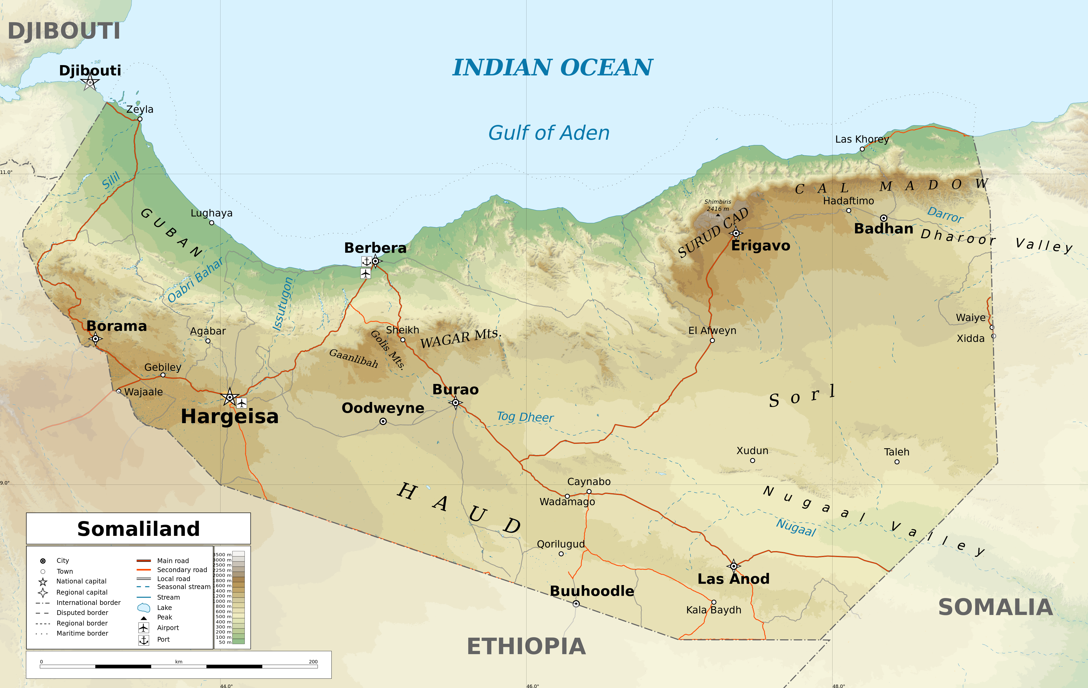
English: Geographic map of Somaliland. Geographic limits of the map:
|
| Dáta | |
| Foinse |
Obair féin
|
| Údar | Ikonact |
| Ceadúnas (Athúsáid a bhaint as an gcomhad seo) |
Any use of this map is subject of the license(s) stated below with the condition that you credit (Wikimedia Commons user: Ikonact) as the author . A message with a reply address would also be greatly appreciated. |
| Leaganacha eile |
[]
|
| SVG genesis |


Assessment
|
Ceadúnú
Is mise sealbhóir cóipchirt an shaothair seo agus foilsím é faoin gceadúnas seo a leanas:
This file is licensed under the Creative Commons Attribution-Share Alike 4.0 International license.
- Is féidir:
- an saothar seo a roinnt – an saothar seo a chóipeáil, a dháil amach, agus a tharchur
- an saothar seo a athmheascadh – an saothar seo a oiriúnú
- Ach amháin má leantar na coinníollacha seo a leanas:
- sannadh – Ní mor creidiúint a thabhairt leis an saothar, faoi mar a shonraigh an údar nó tabharthóir an ceadúnais (ach ná húsáid modh a thugann le fios go thacaíonn sé/sí tú féin nó an úsáid a bhaineann tú as an saothar).
- comhroinn araon – Má athraíonn tú nó síneann tú amach an saothar seo, ní féidir é a dháileadh ach amhaín faoin gceadúnas céanna nó ceann cosúil leis an gceann seo.
Stair chomhaid
Cliceáil ar dáta/am chun an comhad a radharc mar a bhí sé ag an am sin.
| Dáta/Am | Mionsamhail | Toisí | Úsáideoir | Nóta tráchta | |
|---|---|---|---|---|---|
| faoi láthair | 17:20, 13 Feabhra 2022 | | 4,110 × 2,600 (11.09 MB) | Jacob300 | Reverted to version as of 22:29, 26 August 2021 (UTC) |
| 08:01, 27 Lúnasa 2021 |  | 4,110 × 2,600 (11.27 MB) | Ikonact | Reverted to version as of 11:59, 26 August 2021 (UTC) - the eastern border is disputed and should stay as such | |
| 22:29, 26 Lúnasa 2021 |  | 4,110 × 2,600 (11.09 MB) | Siirski | Corrected eastern border | |
| 11:59, 26 Lúnasa 2021 |  | 4,110 × 2,600 (11.27 MB) | Ikonact | final touch | |
| 09:37, 26 Lúnasa 2021 |  | 4,110 × 2,600 (11.36 MB) | Ikonact | legend, names in En | |
| 20:47, 25 Lúnasa 2021 |  | 4,110 × 2,600 (11.33 MB) | Ikonact | + mnts nammes | |
| 20:07, 25 Lúnasa 2021 |  | 4,110 × 2,600 (11.32 MB) | Ikonact | font | |
| 20:03, 25 Lúnasa 2021 |  | 4,110 × 2,600 (11.32 MB) | Ikonact | more data | |
| 12:56, 24 Lúnasa 2021 |  | 4,110 × 2,600 (16.17 MB) | Ikonact | == {{int:filedesc}} == {{Information |description={{en|Geographic map of {{W|Somaliland}}. Geographic limits of the map:}} *N: 12.12° N *S: 7.69° N *W: 42.56° E *E: 49.67° E Equidistant Cylindrical projection; WGS 84 datum |date=2021-08-24 |source={{own}} *Sources of data:<br/> **Topography: SRTM3 v4 (public domain);<br/> **Rivers and water bodies: Natural Earth, © OpenStreetMap contributors **Borders and towns: © OpenStreetMap contributors;<br/> *Tool:<br/> **The map is created with Octave s... |
Úsáid comhaid
Tá nasc chuig an gcomhad seo ar na leathanaigh seo a leanas:
Global file usage
The following other wikis use this file:
- Úsáid ar ar.wikipedia.org
- Úsáid ar bg.wikipedia.org
- Úsáid ar ca.wikipedia.org
- Úsáid ar da.wikipedia.org
- Úsáid ar de.wikipedia.org
- Úsáid ar en.wikipedia.org
- Úsáid ar fr.wikipedia.org
- Úsáid ar gl.wikipedia.org
- Úsáid ar hu.wikipedia.org
- Úsáid ar id.wikipedia.org
- Úsáid ar is.wikipedia.org
- Úsáid ar ja.wikipedia.org
- Úsáid ar ku.wikipedia.org
- Úsáid ar lt.wikipedia.org
- Úsáid ar ru.wikivoyage.org
- Úsáid ar sh.wikipedia.org
- Úsáid ar so.wikipedia.org
- Úsáid ar sv.wikipedia.org
- Úsáid ar www.wikidata.org
- Úsáid ar zh.wikipedia.org