Íomhá:Glenrothes with Thornton railway station - geograph.org.uk - 946078.jpg
Níl aon taifeach is mó ar fáil.
Glenrothes_with_Thornton_railway_station_-_geograph.org.uk_-_946078.jpg (640 × 480 picteilín, méid comhaid: 97 KB, cineál MIME: image/jpeg)
| Seo comhad as An Cómhaoin Viciméid. Tá an tuairisc as an leathanach tuairisc Cómhaoin a leanas thíos.
|
Achoimriú
| Tuairisc |
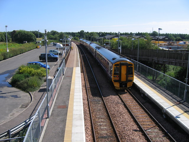
English: Glenrothes with Thornton railway station Viewed from Main Street bridge, Thornton, a five-coach Fife Circle train stands at Platform 1, waiting to depart for Edinburgh via Kirkcaldy. Although apparently a conventional double-track station, things are not quite what they seem. Most Fife Circle trains use Platform 1 in both directions. Platform 2 is used only by a few trains in the peak periods, running to or from Markinch and Perth. The two tracks diverge respectively south and north round the curve in the background. Immediately east of Main Street bridge crossovers between the two tracks mark the start of normal Up and Down double track. In the left background, half-hidden behind a bush, is the derelict winding house of a former coal pit. |
| Dáta | |
| Foinse | From geograph.org.uk |
| Údar | A-M-Jervis |
| Creidiúint (required by the license) | A-M-Jervis / Glenrothes with Thornton railway station / |
| Camera location | | View this and other nearby images on: OpenStreetMap |
|---|
_heading:90.00&language=ga)
| Object location | | View this and other nearby images on: OpenStreetMap |
|---|
_heading:90.00&language=ga)
Ceadúnú

|
This image was taken from the Geograph project collection. See this photograph's page on the Geograph website for the photographer's contact details. The copyright on this image is owned by A-M-Jervis and is licensed for reuse under the Creative Commons Attribution-ShareAlike 2.0 license.
|
This file is licensed under the Creative Commons Attribution-Share Alike 2.0 Generic license.
Creidiúint: A-M-Jervis
- Is féidir:
- an saothar seo a roinnt – an saothar seo a chóipeáil, a dháil amach, agus a tharchur
- an saothar seo a athmheascadh – an saothar seo a oiriúnú
- Ach amháin má leantar na coinníollacha seo a leanas:
- sannadh – Ní mor creidiúint a thabhairt leis an saothar, faoi mar a shonraigh an údar nó tabharthóir an ceadúnais (ach ná húsáid modh a thugann le fios go thacaíonn sé/sí tú féin nó an úsáid a bhaineann tú as an saothar).
- comhroinn araon – Má athraíonn tú nó síneann tú amach an saothar seo, ní féidir é a dháileadh ach amhaín faoin gceadúnas céanna nó ceann cosúil leis an gceann seo.
Stair chomhaid
Cliceáil ar dáta/am chun an comhad a radharc mar a bhí sé ag an am sin.
| Dáta/Am | Mionsamhail | Toisí | Úsáideoir | Nóta tráchta | |
|---|---|---|---|---|---|
| faoi láthair | 09:59, 22 Feabhra 2011 | | 640 × 480 (97 KB) | GeographBot | == {{int:filedesc}} == {{Information |description={{en|1=Glenrothes with Thornton railway station Viewed from Main Street bridge, Thornton, a five-coach Fife Circle train stands at Platform 1, waiting to depart for Edinburgh via Kirkcaldy. Although appar |
Úsáid comhaid
Níl nasc ó aon leathanach eile don íomhá seo.
Global file usage
The following other wikis use this file:
- Úsáid ar en.wikipedia.org