Íomhá:Gulf of Finland NLT Landsat7.png

Size of this preview: 800 × 371 picteilín. Other resolutions: 320 × 148 picteilín | 640 × 297 picteilín | 1,024 × 475 picteilín | 1,280 × 593 picteilín | 2,500 × 1,159 picteilín.
Taispeáin leagan ardtaifigh den íomhá (2,500 × 1,159 picteilín, méid comhaid: 4.79 MB, cineál MIME: image/png)
| Seo comhad as An Cómhaoin Viciméid. Tá an tuairisc as an leathanach tuairisc Cómhaoin a leanas thíos.
|
Achoimriú
| Tuairisc |
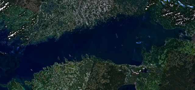
English: Visible colour satellite image of Gulf of Finland.
Русский: Финский залив.
Suomi: Suomenlahti.
Eesti: Soome laht.
Svenska: Finska viken.
Deutsch: Finnische Meerbusen. |
| Dáta | 16 Aibreán 2006 (upload date) |
| Foinse | Satellite imagery taken from NASA World Wind software (by screenshot), NLT Landsat7 layer. |
| Údar | NASA |
Ceadúnú
| This image is in the public domain because it is a screenshot from NASA’s globe software World Wind using a public domain layer, such as Blue Marble, MODIS, Landsat, SRTM, USGS or GLOBE.
|
 |
Stair chomhaid
Cliceáil ar dáta/am chun an comhad a radharc mar a bhí sé ag an am sin.
| Dáta/Am | Mionsamhail | Toisí | Úsáideoir | Nóta tráchta | |
|---|---|---|---|---|---|
| faoi láthair | 16:41, 18 Aibreán 2006 | | 2,500 × 1,159 (4.79 MB) | Hautala | {{PD-WorldWind}} Visible colour satellite image of Gulf of Finland. Screenshot of NASA World Wind, NLT Landsat7 layer. Category:Satellite photos |
Úsáid comhaid
Tá nasc chuig an gcomhad seo ar na leathanaigh seo a leanas:
Global file usage
The following other wikis use this file:
- Úsáid ar ar.wikipedia.org
- Úsáid ar arz.wikipedia.org
- Úsáid ar ast.wikipedia.org
- Úsáid ar ba.wikipedia.org
- Úsáid ar be-tarask.wikipedia.org
- Úsáid ar br.wikipedia.org
- Úsáid ar ca.wikipedia.org
- Úsáid ar cy.wikipedia.org
- Úsáid ar da.wikipedia.org
- Úsáid ar eo.wikipedia.org
- Úsáid ar fy.wikipedia.org
- Úsáid ar he.wikipedia.org
- Úsáid ar hy.wikipedia.org
- Úsáid ar ms.wikipedia.org
- Úsáid ar mzn.wikipedia.org
- Úsáid ar no.wikipedia.org
- Úsáid ar pnb.wikipedia.org
- Úsáid ar pt.wikipedia.org
- Úsáid ar ro.wikipedia.org
- Úsáid ar ru.wikinews.org
- Úsáid ar www.wikidata.org