Íomhá:Haiti Jan2010 ShakeMap.png
Size of this preview: 511 × 600 picteilín. Other resolutions: 204 × 240 picteilín | 409 × 480 picteilín | 779 × 914 picteilín.
Taispeáin leagan ardtaifigh den íomhá (779 × 914 picteilín, méid comhaid: 365 KB, cineál MIME: image/png)
| Seo comhad as An Cómhaoin Viciméid. Tá an tuairisc as an leathanach tuairisc Cómhaoin a leanas thíos.
|
Achoimriú
| Tuairisc |
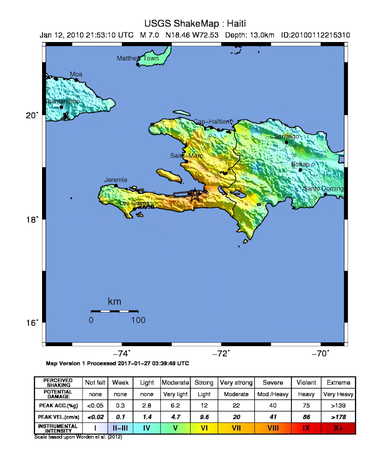
English: USGS ShakeMap of the 2010 Haiti earthquake. |
| Dáta | |
| Foinse | USGS |
| Údar | USGS/Dancraggs |
| Leaganacha eile | 2010 haiti shake map.jpg |
Ceadúnú
This image is in the public domain in the United States because it only contains materials that originally came from the United States Geological Survey, an agency of the United States Department of the Interior. For more information, see the official USGS copyright policy.
|
Stair chomhaid
Cliceáil ar dáta/am chun an comhad a radharc mar a bhí sé ag an am sin.
| Dáta/Am | Mionsamhail | Toisí | Úsáideoir | Nóta tráchta | |
|---|---|---|---|---|---|
| faoi láthair | 00:53, 3 Feabhra 2020 | | 779 × 914 (365 KB) | Tinh1000000 | ATLAS 2017-04-12 revision |
| 00:02, 23 Eanáir 2010 |  | 721 × 914 (211 KB) | AtomCrusher | {{Information |Description={{en|1=USGS ShakeMap v7, data re-rendered and anti-aliased by user.}} |Source=http://earthquake.usgs.gov/earthquakes/shakemap/global/shake/2010rja6/ |Author=USGS/Dancraggs |Date=2010-01-13 |Permission= |ot |
Úsáid comhaid
Tá nasc chuig an gcomhad seo ar na leathanaigh seo a leanas:
Global file usage
The following other wikis use this file:
- Úsáid ar ast.wikipedia.org
- Úsáid ar az.wikipedia.org
- Úsáid ar ca.wikipedia.org
- Úsáid ar en.wikipedia.org
- Úsáid ar es.wikipedia.org
- Úsáid ar eu.wikipedia.org
- Úsáid ar it.wikipedia.org
- Úsáid ar lad.wikipedia.org
- Úsáid ar nn.wikipedia.org
- Úsáid ar pt.wikipedia.org
- Úsáid ar ru.wikipedia.org
- Úsáid ar sk.wikipedia.org
- Úsáid ar www.wikidata.org
- Úsáid ar zh-min-nan.wikipedia.org
- Úsáid ar zh.wikipedia.org