Íomhá:ISS-20 Caribbean island of Hispaniola from the ISS.jpg
Size of this preview: 800 × 532 picteilín. Other resolutions: 320 × 213 picteilín | 640 × 426 picteilín | 1,024 × 681 picteilín | 1,280 × 852 picteilín | 2,560 × 1,703 picteilín | 4,256 × 2,832 picteilín.
Taispeáin leagan ardtaifigh den íomhá (4,256 × 2,832 picteilín, méid comhaid: 1.17 MB, cineál MIME: image/jpeg)
| Seo comhad as An Cómhaoin Viciméid. Tá an tuairisc as an leathanach tuairisc Cómhaoin a leanas thíos.
|
Achoimriú
| Tuairisc |
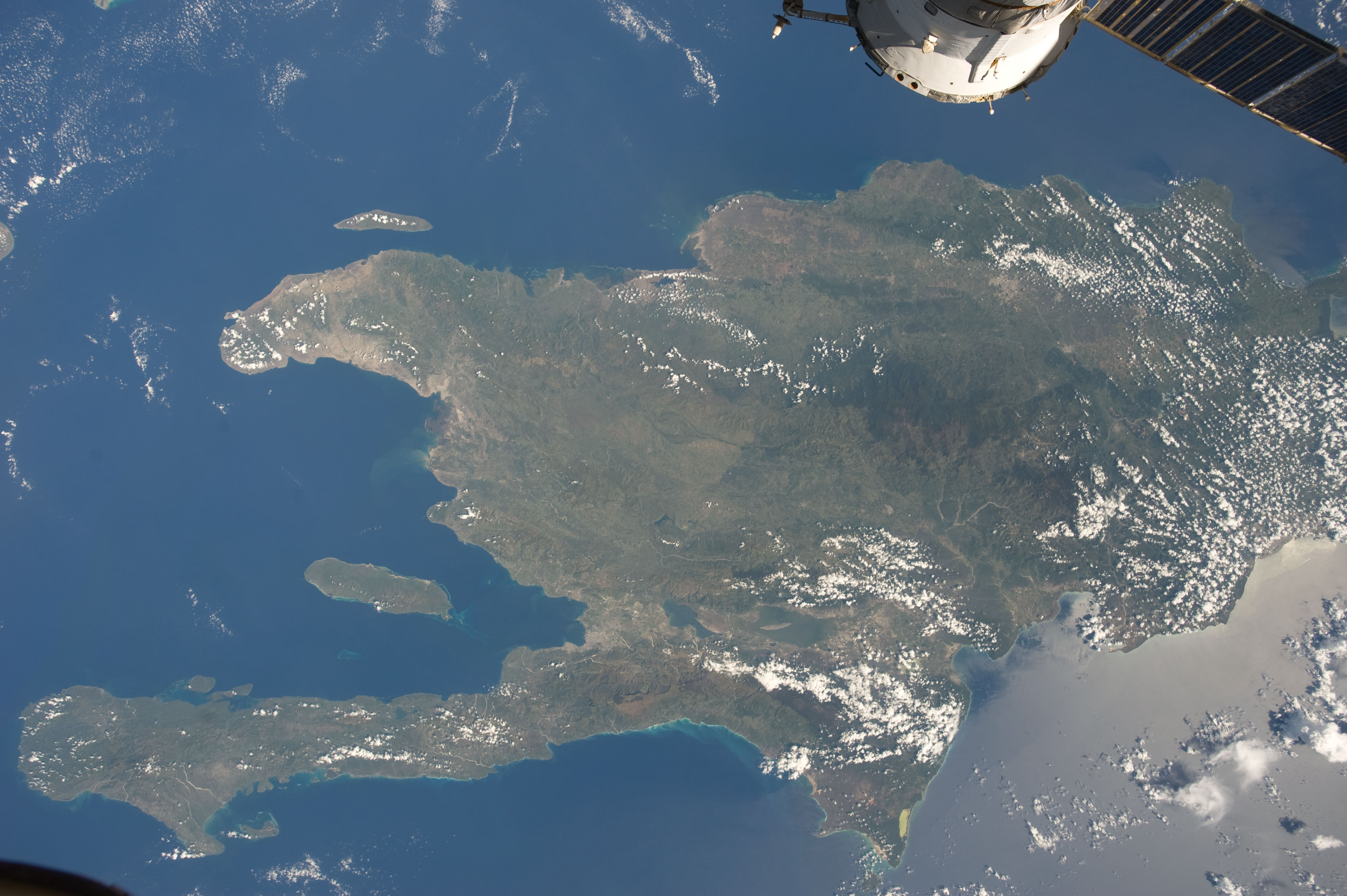
English: A view of the Caribbean island of Hispaniola from the International Space Station. This island is comprised of Haiti (in the center left of the image) and the Dominican Republic and is part of the Greater Antilles island chain which lies along the geological border of the North America Plate and the Caribbean Plate. A major fault line in the region, Enriquillo-Plantain Garden Fault, runs along the longer peninsula, in the foreground, and just south of Port-au-Prince. Part of a docked Russian spacecraft can be seen in the foreground. The epicenter of the disastrous 2010 earthquake occurred near this fault. This image was taken by the Expedition 20 crew on the International Space Station on Sept. 28, 2009 using a 25 mm lens setting. |
| Dáta | |
| Foinse | http://spaceflight.nasa.gov/gallery/images/station/crew-20/html/iss020e043301.html |
| Údar | NASA/Expedition 20 crew |
| Leaganacha eile |
This image or video was catalogued by Johnson Space Center of the United States National Aeronautics and Space Administration (NASA) under Photo ID: ISS020-E-043301. This tag does not indicate the copyright status of the attached work. A normal copyright tag is still required. See Commons:Licensing. Other languages:
|
Ceadúnú
| Chruthaigh NASA an comhad seo, agus tógadh as suíomh Greasáin NASA nó foilseachán NASA é. Tá gach saothar den saghas sin sa fearann poiblí ach amháin an suaitheantas NASA, mar ní féidir saothair de chuid rialtas cónaidhme Stáit Aontaithe Mheiriceá a chur faoi chóipcheart. Féach ar an leathanach pholasaí cóipchirt NASA nó an leathanach pholasaí íomhanna JPL le tuilleadh eolais. | ||
 |
Rabhaidh:
|
Stair chomhaid
Cliceáil ar dáta/am chun an comhad a radharc mar a bhí sé ag an am sin.
| Dáta/Am | Mionsamhail | Toisí | Úsáideoir | Nóta tráchta | |
|---|---|---|---|---|---|
| faoi láthair | 20:18, 22 Meitheamh 2012 | | 4,256 × 2,832 (1.17 MB) | Ras67 | {{Information |Description={{en|1=A view of the Caribbean island of Hispaniola from the International Space Station. This island is comprised of Haiti (in the center left of the image) and the Dominican Republic and is part of the Greater Antilles isla... |
Úsáid comhaid
Tá nasc chuig an gcomhad seo ar na leathanaigh seo a leanas:
Global file usage
The following other wikis use this file:
- Úsáid ar ar.wikipedia.org
- Úsáid ar ast.wikipedia.org
- Úsáid ar az.wikipedia.org
- Úsáid ar ba.wikipedia.org
- Úsáid ar ca.wikipedia.org
- Úsáid ar ceb.wikipedia.org
- Úsáid ar cy.wikipedia.org
- Úsáid ar de.wikipedia.org
- Úsáid ar es.wikipedia.org
- Úsáid ar eu.wikipedia.org
- Úsáid ar fi.wiktionary.org
- Úsáid ar fr.wikivoyage.org
- Úsáid ar hsb.wikipedia.org
- Úsáid ar ht.wikipedia.org
- Úsáid ar hy.wikipedia.org
- Úsáid ar ia.wikipedia.org
- Úsáid ar lb.wikipedia.org
- Úsáid ar no.wikipedia.org
- Úsáid ar pap.wikipedia.org
- Úsáid ar pl.wikipedia.org
- Úsáid ar pnb.wikipedia.org
- Úsáid ar ro.wikipedia.org
- Úsáid ar sv.wikipedia.org
- Úsáid ar tg.wikipedia.org
- Úsáid ar uk.wikipedia.org
- Úsáid ar uz.wikipedia.org
- Úsáid ar vec.wikipedia.org
- Úsáid ar www.wikidata.org