Íomhá:Is-map.PNG
Size of this preview: 276 × 598 picteilín. Other resolutions: 110 × 240 picteilín | 329 × 713 picteilín.
Taispeáin leagan ardtaifigh den íomhá (329 × 713 picteilín, méid comhaid: 27 KB, cineál MIME: image/png)
| Seo comhad as An Cómhaoin Viciméid. Tá an tuairisc as an leathanach tuairisc Cómhaoin a leanas thíos.
|
| Tuairisc |
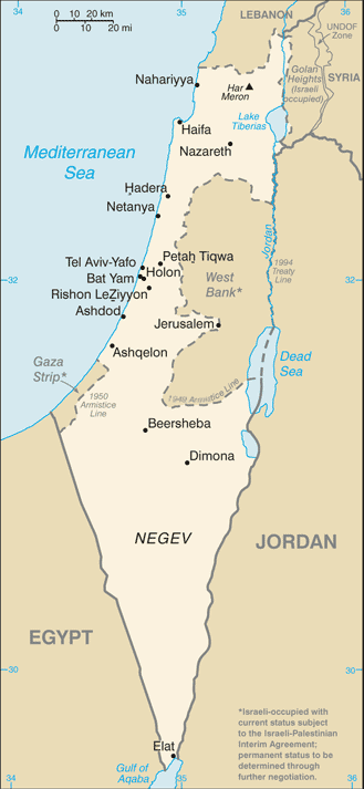
Русский: Карта Израиля |
| Dáta | (2004) |
| Foinse | CIA-WF |
| Údar | CIA |
| Leaganacha eile |
.png)
This image is in the public domain because it contains materials that originally came from the United States Central Intelligence Agency's World Factbook.
|
 |
Stair chomhaid
Cliceáil ar dáta/am chun an comhad a radharc mar a bhí sé ag an am sin.
| Dáta/Am | Mionsamhail | Toisí | Úsáideoir | Nóta tráchta | |
|---|---|---|---|---|---|
| faoi láthair | 07:25, 21 Meitheamh 2007 | | 329 × 713 (27 KB) | Hoshie | Updated map of Israel from the CIA World Factbook, 14 June 07 rev. Src: https://www.cia.gov/library/publications/the-world-factbook/maps/is-map.gif |
| 14:27, 16 Meitheamh 2005 |  | 330 × 715 (24 KB) | Csörföly D | Category:Maps of Israel {{PD-USGov-CIA-PD}} |
Úsáid comhaid
Níl nasc ó aon leathanach eile don íomhá seo.
Global file usage
The following other wikis use this file:
- Úsáid ar ar.wikipedia.org
- Úsáid ar bg.wikipedia.org
- Úsáid ar bn.wikipedia.org
- Úsáid ar bs.wikipedia.org
- Úsáid ar ca.wikipedia.org
- Úsáid ar de.wikipedia.org
- Úsáid ar en.wikipedia.org
- History of Israel
- Israeli Declaration of Independence
- Israeli settlement
- Zionism
- Israeli–Palestinian conflict
- Law of Return
- Demographic history of Palestine (region)
- User talk:Theblackbay
- Israel
- Chronology of Aliyah in modern times
- History of Palestine
- Timeline of the name Palestine
- Template:Zionism and the Land of Israel
- Land of Israel
- Module:Location map/data/Israel/doc
- Module:Location map/data/Israel
- User:প্রলয়স্রোত/sandbox
- List of journalists killed during the Israeli–Palestinian conflict
- Israeli war crimes
- Wikipedia:In the news/Posted/February 2005
- Hamas war crimes
- Úsáid ar en.wikinews.org
- Úsáid ar es.wikipedia.org
- Úsáid ar eu.wikipedia.org
- Úsáid ar fi.wikipedia.org
- Úsáid ar fi.wikivoyage.org
- Úsáid ar fr.wikipedia.org
- Úsáid ar fr.wikinews.org
- Úsáid ar hif.wikipedia.org
- Úsáid ar hi.wikipedia.org
- Úsáid ar hr.wikipedia.org
- Úsáid ar hy.wikipedia.org
- Úsáid ar ilo.wikipedia.org
- Úsáid ar it.wikinews.org
View more global usage of this file.