Íomhá:Map of Finland-en.svg

Size of this PNG preview of this SVG file: 409 × 599 picteilín. Other resolutions: 164 × 240 picteilín | 328 × 480 picteilín | 524 × 768 picteilín | 699 × 1,024 picteilín | 1,399 × 2,048 picteilín | 1,371 × 2,007 picteilín.
Taispeáin leagan ardtaifigh den íomhá (Comhad SVG, ainmniúil 1,371 × 2,007 picteilíni, méid comhaid: 3.57 MB)
| Seo comhad as An Cómhaoin Viciméid. Tá an tuairisc as an leathanach tuairisc Cómhaoin a leanas thíos.
|
Achoimriú
| Tuairisc |
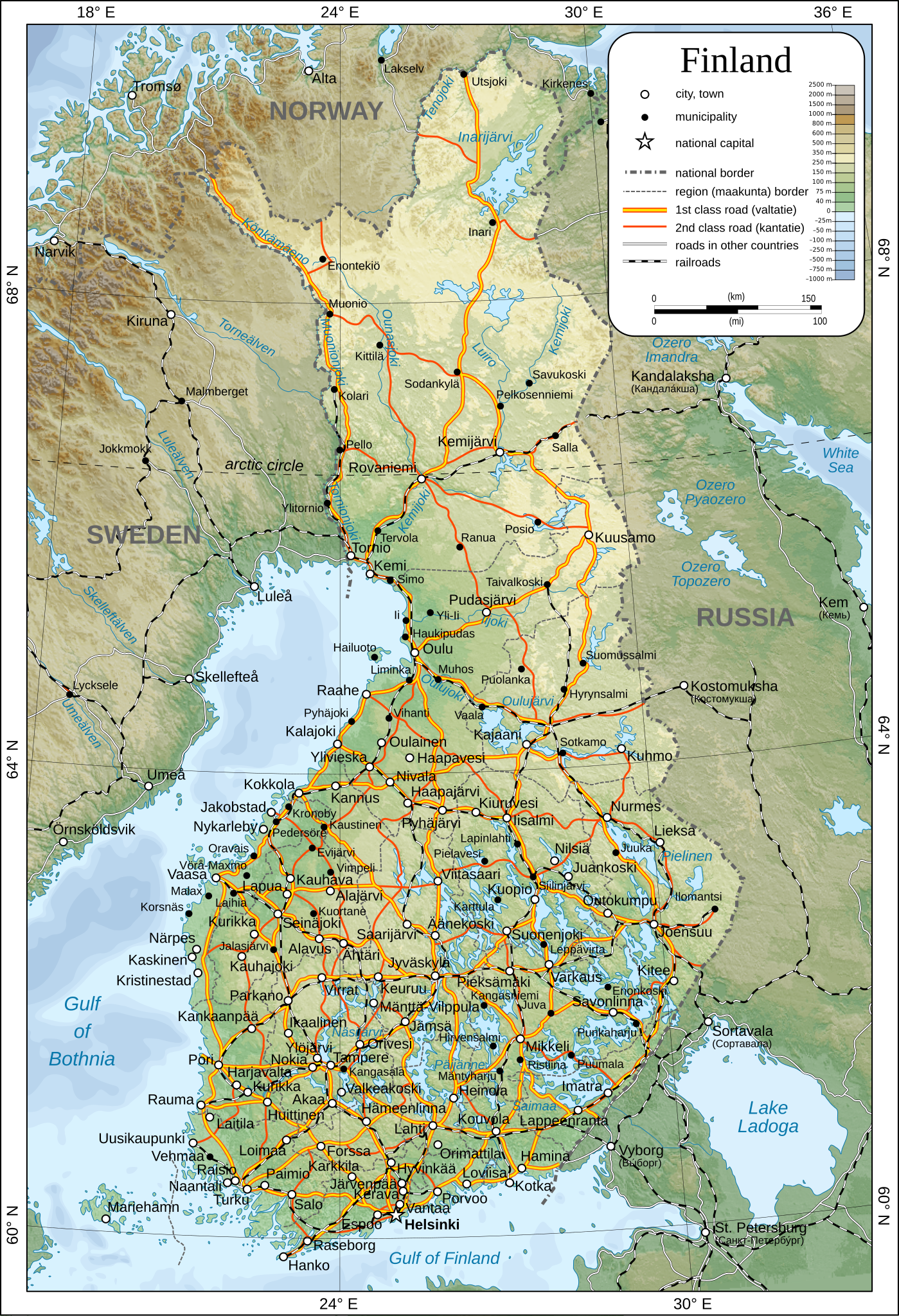
English: Map of Finland.
Suomi: Suomen kartta.
Svenska: Karta över Finland.
|
| Dáta | |
| Foinse | Obair féin |
| Údar | Oona Räisänen |
| Ceadúnas (Athúsáid a bhaint as an gcomhad seo) |
See below. I've worked hard to create this map, so even though not mandatory, please attribute me wherever it is suitable. |
| Leaganacha eile |
[]
|
| SVG genesis |


Ceadúnú
| I, the copyright holder of this work, release this work into the public domain. This applies worldwide. In some countries this may not be legally possible; if so: I grant anyone the right to use this work for any purpose, without any conditions, unless such conditions are required by law. |
Stair chomhaid
Cliceáil ar dáta/am chun an comhad a radharc mar a bhí sé ag an am sin.
| Dáta/Am | Mionsamhail | Toisí | Úsáideoir | Nóta tráchta | |
|---|---|---|---|---|---|
| faoi láthair | 13:44, 26 Nollaig 2009 | | 1,371 × 2,007 (3.57 MB) | Mysid | added some cities, municipalities, and height color legend |
| 10:18, 24 Nollaig 2009 |  | 1,371 × 2,007 (3.46 MB) | Mysid | updated with topography, bathymetry, and revised provinces | |
| 00:40, 5 Márta 2009 |  | 1,371 × 2,007 (886 KB) | Mysid | fonts | |
| 00:37, 5 Márta 2009 |  | 1,371 × 2,007 (885 KB) | Mysid | {{Information |Description={{en|1=Map of w:Finland.}} {{fi|1=Suomen kartta.}} {{sv|1=Karta över sv:Finland.}} |Source=Self-made in Inkscape after CIA. |Author=Mysid |Date=2009-03-05 |Permission= |other_versions= |
Úsáid comhaid
Níl nasc ó aon leathanach eile don íomhá seo.
Global file usage
The following other wikis use this file:
- Úsáid ar af.wikipedia.org
- Úsáid ar ar.wikipedia.org
- Úsáid ar avk.wikipedia.org
- Úsáid ar be.wikipedia.org
- Úsáid ar bg.wikipedia.org
- Úsáid ar cs.wikipedia.org
- Úsáid ar cy.wikipedia.org
- Úsáid ar de.wikipedia.org
- Úsáid ar en.wikipedia.org
- Úsáid ar fa.wikipedia.org
- Úsáid ar fr.wikipedia.org
- Úsáid ar he.wikipedia.org
- Úsáid ar hr.wiktionary.org
- Úsáid ar hy.wikipedia.org
- Úsáid ar io.wikipedia.org
- Úsáid ar ja.wikipedia.org
- Úsáid ar ka.wikipedia.org
- Úsáid ar mk.wikipedia.org
- Úsáid ar nl.wikipedia.org
- Úsáid ar pl.wikipedia.org
- Úsáid ar pl.wiktionary.org
- Úsáid ar pnb.wikipedia.org
- Úsáid ar rm.wikipedia.org
- Úsáid ar ro.wikipedia.org
- Úsáid ar ru.wikipedia.org
- Úsáid ar sco.wikipedia.org
- Úsáid ar simple.wikipedia.org
- Úsáid ar sr.wikipedia.org
- Úsáid ar tr.wikipedia.org
- Úsáid ar uk.wikipedia.org
- Úsáid ar zh.wikipedia.org