Íomhá:North ossetia alania map.png

Size of this preview: 534 × 599 picteilín. Other resolutions: 214 × 240 picteilín | 428 × 480 picteilín | 720 × 808 picteilín.
Taispeáin leagan ardtaifigh den íomhá (720 × 808 picteilín, méid comhaid: 53 KB, cineál MIME: image/png)
| Seo comhad as An Cómhaoin Viciméid. Tá an tuairisc as an leathanach tuairisc Cómhaoin a leanas thíos.
|
Achoimriú
| Tuairisc |
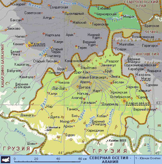
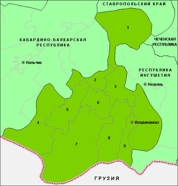
English: Map of the Republic of North Ossetia-Alania. |
| Dáta | |
| Foinse | Obair féin |
| Údar | PANONIAN |
Ceadúnú
Is mise sealbhóir cóipchirt an shaothair seo agus foilsím é faoin gceadúnas seo a leanas:
| This file is made available under the Creative Commons CC0 1.0 Universal Public Domain Dedication. | |
| The person who associated a work with this deed has dedicated the work to the public domain by waiving all of their rights to the work worldwide under copyright law, including all related and neighboring rights, to the extent allowed by law. You can copy, modify, distribute and perform the work, even for commercial purposes, all without asking permission.
|
References
Maps from external links:
- http://www.skppk.ru/i/map/osetiya_region_map.jpg
- http://ossetians.com/pictures/Map_1.jpg
- http://topwar.ru/uploads/posts/2011-06/1309189225_alania_karta.jpg
- http://www.stopwatchhut.com/places/770.jpg
- http://nocss.ru/projects/10/images/map-1.jpg
- http://karty.narod.ru/maps/sosetia/s-osetia.GIF
- http://obkom.com/russia/fussr/osetiya-yuzhnaya/images/karta-osetia-sev-yuzh.jpg
- http://karta-russia.ru/maps/map-severnaya-osetiya-karta.jpg
- http://alcoinf.com/images/severnaya-osetiya.gif
- http://sif.ru/images/maps/Severnaya-Osetiya2.gif
- http://region15.ru/img/territor/map-adm.gif
- http://www.hge.pu.ru/mapgis/subekt/osetia/osetia.gif
- http://www.smsr-senclub.ru/upload/medialibrary/ece/ece341c19c79030e09063fff6763d2d5.jpg
- http://www.rossadovod.ru/regions/osetia-alania/map.jpg
- http://www.ntsomz.ru/img/severnaya%20osetiya_800x566.jpg
- http://trasa.ru/img/regions/sevosetiya.gif
- http://dic.academic.ru/pictures/enc_geo/Severnaya_Osetia-Alania.jpg
- http://geo.1september.ru/2008/22/40-1.jpg
- http://openbudget.karelia.ru/budnord/russian/north-caucasian/northern-ossetiya-republic/images/karta_alania.jpg
List of largest cities and towns:
Stair chomhaid
Cliceáil ar dáta/am chun an comhad a radharc mar a bhí sé ag an am sin.
| Dáta/Am | Mionsamhail | Toisí | Úsáideoir | Nóta tráchta | |
|---|---|---|---|---|---|
| faoi láthair | 06:51, 17 Meitheamh 2012 | | 720 × 808 (53 KB) | PANONIAN | {{Information |Description ={{en|1=Map of the Republic of North Ossetia-Alania.}} |Source ={{own}} |Author =PANONIAN |Date =2012 |Permission = |other_versions = }} |
Úsáid comhaid
Tá nasc chuig an gcomhad seo ar na leathanaigh seo a leanas:
Global file usage
The following other wikis use this file:
- Úsáid ar ace.wikipedia.org
- Úsáid ar ast.wikipedia.org
- Úsáid ar az.wikipedia.org
- Úsáid ar ba.wikipedia.org
- Úsáid ar be-tarask.wikipedia.org
- Úsáid ar be.wikipedia.org
- Úsáid ar bg.wikipedia.org
- Úsáid ar br.wikipedia.org
- Úsáid ar bs.wikipedia.org
- Úsáid ar bxr.wikipedia.org
- Úsáid ar ce.wikipedia.org
- Úsáid ar cs.wikipedia.org
- Úsáid ar cv.wikipedia.org
- Úsáid ar diq.wikipedia.org
- Úsáid ar en.wikipedia.org
- Úsáid ar es.wikipedia.org
- Úsáid ar et.wikipedia.org
- Úsáid ar eu.wikipedia.org
- Úsáid ar fo.wikipedia.org
- Úsáid ar gl.wikipedia.org
- Úsáid ar got.wikipedia.org
- Úsáid ar hy.wikipedia.org
- Úsáid ar id.wikipedia.org
- Úsáid ar is.wikipedia.org
- Úsáid ar it.wikipedia.org
- Úsáid ar ka.wikipedia.org
- Úsáid ar kbd.wikipedia.org
- Úsáid ar koi.wikipedia.org
- Úsáid ar krc.wikipedia.org
- Úsáid ar kv.wikipedia.org
- Úsáid ar la.wikipedia.org
- Úsáid ar lbe.wikipedia.org
- Úsáid ar lmo.wikipedia.org
- Úsáid ar lt.wikipedia.org
- Úsáid ar mhr.wikipedia.org
- Úsáid ar mn.wikipedia.org
- Úsáid ar mr.wikipedia.org
- Úsáid ar ms.wikipedia.org
- Úsáid ar myv.wikipedia.org
- Úsáid ar nn.wikipedia.org
- Úsáid ar pnb.wikipedia.org
- Úsáid ar ps.wikipedia.org
- Úsáid ar ro.wikipedia.org
- Úsáid ar rw.wikipedia.org
- Úsáid ar sah.wikipedia.org
- Úsáid ar scn.wikipedia.org
- Úsáid ar sco.wikipedia.org
- Úsáid ar se.wikipedia.org
- Úsáid ar simple.wikipedia.org
View more global usage of this file.