Íomhá:Philadelphia skyline from South Street Bridge January 2020 (rotate 2 degrees perspective correction crop 4-1).jpg

Size of this preview: 800 × 200 picteilín. Other resolutions: 320 × 80 picteilín | 640 × 160 picteilín | 1,024 × 256 picteilín | 3,816 × 954 picteilín.
Taispeáin leagan ardtaifigh den íomhá (3,816 × 954 picteilín, méid comhaid: 1.42 MB, cineál MIME: image/jpeg)
| Seo comhad as An Cómhaoin Viciméid. Tá an tuairisc as an leathanach tuairisc Cómhaoin a leanas thíos.
|
Achoimriú
| Tuairisc |
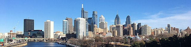
English: The skyline of Philadelphia, Pennsylvania viewed from the South Street Bridge over the Schuylkill River. If on Wikipedia, see the fully annotated version on the Wikimedia page.
|
||
| Dáta | |||
| Foinse | File:Philadelphia_skyline_from_South_Street_Bridge_January_2020.jpeg | ||
| Údar | Dough4872; modifications and annotations by Maps and stuff (Brian W. Schaller) | ||
| Leaganacha eile |
|

.jpg)
| Camera location | | View this and other nearby images on: OpenStreetMap |
|---|
.jpg¶ms=039.946975_N_-075.186797_E_globe:Earth_type:camera_heading:69.51&language=ga)
Ceadúnú
This file is licensed under the Creative Commons Attribution-Share Alike 4.0 International license.
- Is féidir:
- an saothar seo a roinnt – an saothar seo a chóipeáil, a dháil amach, agus a tharchur
- an saothar seo a athmheascadh – an saothar seo a oiriúnú
- Ach amháin má leantar na coinníollacha seo a leanas:
- sannadh – Ní mor creidiúint a thabhairt leis an saothar, faoi mar a shonraigh an údar nó tabharthóir an ceadúnais (ach ná húsáid modh a thugann le fios go thacaíonn sé/sí tú féin nó an úsáid a bhaineann tú as an saothar).
- comhroinn araon – Má athraíonn tú nó síneann tú amach an saothar seo, ní féidir é a dháileadh ach amhaín faoin gceadúnas céanna nó ceann cosúil leis an gceann seo.
| Annotations | This image is annotated: View the annotations at Commons |
Stair chomhaid
Cliceáil ar dáta/am chun an comhad a radharc mar a bhí sé ag an am sin.
| Dáta/Am | Mionsamhail | Toisí | Úsáideoir | Nóta tráchta | |
|---|---|---|---|---|---|
| faoi láthair | 14:22, 27 Eanáir 2020 | 3,816 × 954 (1.42 MB) | Maps and stuff | User created page with UploadWizard |
Úsáid comhaid
Tá nasc chuig an gcomhad seo ar na leathanaigh seo a leanas:
Global file usage
The following other wikis use this file:
- Úsáid ar ang.wikipedia.org
- Úsáid ar ar.wikipedia.org
- Úsáid ar arz.wikipedia.org
- Úsáid ar ast.wikipedia.org
- Úsáid ar br.wikipedia.org
- Úsáid ar ca.wikipedia.org
- Úsáid ar ce.wikipedia.org
- Úsáid ar ckb.wikipedia.org
- Úsáid ar cy.wikipedia.org
- Úsáid ar da.wikipedia.org
- Úsáid ar de.wikivoyage.org
- Úsáid ar diq.wikipedia.org
- Úsáid ar en.wikipedia.org
- Úsáid ar en.wikibooks.org
- Úsáid ar en.wikivoyage.org
- Úsáid ar eu.wikipedia.org
- Úsáid ar fr.wikivoyage.org
- Úsáid ar gl.wikipedia.org
- Úsáid ar ha.wikipedia.org
- Úsáid ar he.wikivoyage.org
- Úsáid ar ht.wikipedia.org
- Úsáid ar ia.wikipedia.org
- Úsáid ar ilo.wikipedia.org
- Úsáid ar incubator.wikimedia.org
- Úsáid ar it.wikipedia.org
- Úsáid ar it.wikivoyage.org
- Úsáid ar ja.wikivoyage.org
- Úsáid ar kab.wikipedia.org
- Úsáid ar lb.wikipedia.org
- Úsáid ar lld.wikipedia.org
- Úsáid ar mhr.wikipedia.org
- Úsáid ar no.wikipedia.org
- Úsáid ar ru.wikipedia.org
- Úsáid ar ru.wikinews.org
- Úsáid ar simple.wikipedia.org
- Úsáid ar sr.wikipedia.org
View more global usage of this file.
.jpg)
.jpg)