Íomhá:San Francisco in ruin edit2.jpg
Taispeáin leagan ardtaifigh den íomhá (7,000 × 2,748 picteilín, méid comhaid: 4.32 MB, cineál MIME: image/jpeg)

Seo comhad as An Cómhaoin Viciméid. Tá an tuairisc as an leathanach tuairisc Cómhaoin a leanas thíos.
Is stór comhaid meáin Saor é an Cómhaoin Viciméid. Is féidir leat cabhrú.

Achoimriú

Featured íomhá

Cómhaoin Wikimediaan Vicipéid

This is a featured picture on Wikimedia Commons (Featured pictures) and is considered one of the finest images. See its nomination here.

 This is a featured picture on the English language Wikipedia (Featured pictures) and is considered one of the finest images. See its nomination here.
 This is a featured picture on the Turkish language Wikipedia (Seçkin resimler) and is considered one of the finest images. See its nomination here.

If you have an image of similar quality that can be published under a suitable copyright license, be sure to upload it, tag it, and nominate it.

Tuairisc
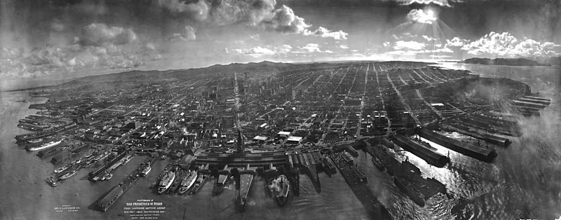
Deutsch: San Francisco in Ruinen am 28. Mai 1906, etwa 6 Wochen nach Erdbeben vom 18. April 1906 und Brand. Laut Kopierschablone aus 2000 Fuß (610 m) Höhe vom "Lawrence Captive Airship" fotografiert. Lawrence meinte damit eine Kette aus Drachen.
English: San Francisco lies in ruins on May 28, 1906, about six weeks after the 1906 San Francisco earthquake and fire. It was taken from a camera suspended on a kite, perhaps 1,000 feet above the city. It is one of the most well-known photographs of George R. Lawrence (see biography for more information about the technique used). The tower of the Ferry Building can be seen at the bay end of Market Street, which can be clearly seen all the way to the foothills of Twin Peaks. The water in the foreground is San Francisco Bay, with the Golden Gate to the right, rear. Note the absence of the Golden Gate Bridge and the San Francisco-Oakland Bay Bridge, which had yet to be constructed. Source information can be found on the description page of the original image. This is a version edited for the Featured Picture Candidates page.
Français : San Francisco en ruines le 28 mai 1906, six semaines après le Tremblement de terre du 18 avril 1906 et l'incendie qui a suivi. Photo prise à l'aide d'un cerf-volant, d'une altitude de 300 ou 400 mètres. Cette photo est la plus connue de George R. Lawrence. La tour du Ferry Building marque le début de Market Street, qui est visible sur toute sa longueur, jusqu'aux Twin Peaks. Au premier plan, on peut voir la Baie de San Francisco. A droite se trouve le Golden Gate. Les ponts du Golden gate et de la baie n'étaient pas encore construits à l'époque. Plus d'information sur la source est disponible dans la légende de l'image originale.
Dáta
Foinse

Panoramic photographs, Library of Congress, Reproduction number LC-DIG-ppmsca-07823 DLC

This image is available from the United States Library of Congress's Prints and Photographs division
under the digital ID ppmsca.07823.
This tag does not indicate the copyright status of the attached work. A normal copyright tag is still required. See Commons:Licensing.

العربية  беларуская (тарашкевіца)  বাংলা  čeština  Deutsch  English  español  فارسی  suomi  français  galego  עברית  magyar  Bahasa Indonesia  italiano  日本語  Bahaso Melayu Jambi  lietuvių  македонски  മലയാളം  Nederlands  polski  português  português do Brasil  română  русский  sicilianu  slovenčina  slovenščina  Türkçe  українська  中文  中文(简体)  中文(繁體)  +/−

Údar George R. Lawrence (1869-1938), George R. Lawrence Co.
Leaganacha eile

Panoramic photographer Ron Klein, took a similar photograph from approximately the same point in space, 100 years later, using a self built camera very like a George Lawrence model, but because kites are no longer allowed to fly in this airspace, had to use a helicopter.

This is a retouched picture, which means that it has been digitally altered from its original version. Modifications: Edited for the Featured Picture Candidates page. The original can be viewed here: San Francisco in ruins from Lawrence Captive Airship, 1906.jpg. Modifications made by Janke.

References
InfoField
NPR https://www.npr.org/blogs/pictureshow/2014/01/15/260152557/before-drone-cameras-kite-cameras

Ceadúnú

Public domain
Public domain
I Stáit Aontaithe Mheiriceá, tá an chomhad méide seo sa bhfearann poiblí. Ciallaíonn sé seo go bhfoilsíodh don chéad uair an íomhá seo i Stáit Aontaithe Meiriceá roimh an 1 Eanáir 1930. Féach ar an leathanach seo le tuilleadh eolais.

United States
United States
B'fhéidir go bhfuil rialacha eile i bhfeidhm i limistéir údaráis eile, agus b'fhéidir nach bhfuil an íomhá seo sa bhfearann poiblí lasmuigh de Stáit Aontaithe Mhericeá.

Wikipedia upload log

(All user names refer to en.wikipedia)

Previously uploaded to en.wikipedia; description page is/was here. 2006-06-05 upload date by Janke at en.wikipedia

  • 2006-06-05 23:37 Janke 7000×2748×8 (4530695 bytes) Temporary file, edit for FPC {{PD-old}}

Location

The exact location is the intersection the extensions of Market Street and John Street (between Jackson Street and Pacific Avenue).

Captions

Add a one-line explanation of what this file represents

Items portrayed in this file

taispeánann sé/sí

28 Bealtaine 1906Gregorian

media type Béarla

image/jpeg

Stair chomhaid

Cliceáil ar dáta/am chun an comhad a radharc mar a bhí sé ag an am sin.

Dáta/AmMionsamhailToisíÚsáideoirNóta tráchta
faoi láthair01:48, 29 Lúnasa 2007Mionsamhail do leagan ó 01:48, 29 Lúnasa 20077,000 × 2,748 (4.32 MB)Grook Da Oger{{Information |Description=en:San Francisco lies in ruins on May 28, 1906, about six weeks after the en:1906 San Francisco earthquake and fire. It was taken from a camera suspended on a kite 2,000 feet above the city. It is one of the most well

Tá nasc chuig an gcomhad seo ar na leathanaigh seo a leanas:

Global file usage

Úsáidtear an comhad seo ar na vicithe seo a leanas:

View more global usage of this file.

Meiteasonraí