Íomhá:ScotlandSouthAyrshire.png
Níl aon taifeach is mó ar fáil.
ScotlandSouthAyrshire.png (200 × 230 picteilín, méid comhaid: 4 KB, cineál MIME: image/png)
| Seo comhad as An Cómhaoin Viciméid. Tá an tuairisc as an leathanach tuairisc Cómhaoin a leanas thíos.
|
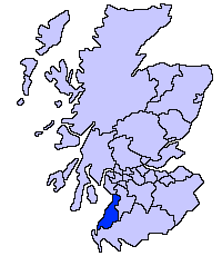
South Ayrshire unitary council
Slightly edited version of a map drawn by Morwen

|
Tugtar cead an doiciméad seo a chóipeáil, a dháileadh agus/nó a mhodhnú faoi théarmaí an Ceadúnas Doiciméadúcháin Saor ó GNU, Leagan 1.2 nó aon leagan níos déanaí a d’fhoilsigh an Fondúireacht Bogearraí Saor in Aisce; gan aon Rannóga Inmheánacha, gan aon Téacsanna Clúdaigh Tosaigh, agus gan aon Téacsanna Clúdaigh Cúil. Tá cóip den cheadúnas san áireamh sa chuid dar teideal Ceadúnas Doiciméadúcháin Saor ó GNU. |
| This file is licensed under the Creative Commons Attribution-Share Alike 3.0 Unported license. | ||
| ||
| This licensing tag was added to this file as part of the GFDL licensing update. |
Stair chomhaid
Cliceáil ar dáta/am chun an comhad a radharc mar a bhí sé ag an am sin.
| Dáta/Am | Mionsamhail | Toisí | Úsáideoir | Nóta tráchta | |
|---|---|---|---|---|---|
| faoi láthair | 21:41, 17 Bealtaine 2005 | | 200 × 230 (4 KB) | Voyager | |
| 21:40, 17 Bealtaine 2005 |  | 200 × 230 (4 KB) | Voyager | South Ayrshire unitary council Slightly edited version of a map drawn by Morwen {{GFDL}} Category:Maps of Scottish unitary councils |
Úsáid comhaid
Níl nasc ó aon leathanach eile don íomhá seo.
Global file usage
The following other wikis use this file:
- Úsáid ar be.wikipedia.org
- Úsáid ar bg.wikipedia.org
- Úsáid ar cy.wikipedia.org
- Úsáid ar de.wikipedia.org
- Úsáid ar en.wikipedia.org
- Úsáid ar eu.wikipedia.org
- Hegoaldeko Ayrshire
- Ayr
- Lankide:Euskaldunaa
- Maybole
- Prestwick
- Txantiloi:Hegoaldeko Ayrshire
- Wikiproiektu:Irlanda, Gales eta Eskoziako udalerriak
- Alloway
- Girvan
- Troon
- Annbank
- Ballantrae
- Barassie (Hegoaldeko Ayrshire)
- Coylton
- Craigie Udalerria eta Parrokia
- Dundonald (South Ayrshire)
- Failford
- Heronsford
- Joppa (Hegoaldeko Ayrshire)
- Loans (Hegoaldeko Ayrshire)
- Millmannoch
- Monkton (Ayrshire)
- Mossblown
- Old Rome (Hegoaldeko Ayrshire)
- Symington (Hegoaldeko Ayrshire)
- Tarbolton
- Barr (Ayrshire)
- Barrhill (Hegoaldeko Ayrshire)
- Colmonell
- Crosshill (Hegoaldeko Ayrshire)
- Dailly
- Dunure
- Kirkmichael
- Kirkoswald (Hegoaldeko Ayrshire)
- Maidens
- Minishant
- Old Dailly
- Straiton
- Belmont (Ayr)
- Doonfoot
- Montgomerieston
- Heathfield (Hegoaldeko Ayrshire)
- Kincaidston
View more global usage of this file.