Íomhá:Vestmann archipel topographic map-fr.svg

Size of this PNG preview of this SVG file: 721 × 600 picteilín. Other resolutions: 289 × 240 picteilín | 577 × 480 picteilín | 923 × 768 picteilín | 1,231 × 1,024 picteilín | 2,462 × 2,048 picteilín | 887 × 738 picteilín.
Taispeáin leagan ardtaifigh den íomhá (Comhad SVG, ainmniúil 887 × 738 picteilíni, méid comhaid: 323 KB)
| Seo comhad as An Cómhaoin Viciméid. Tá an tuairisc as an leathanach tuairisc Cómhaoin a leanas thíos.
|
Achoimriú
| Tuairisc |
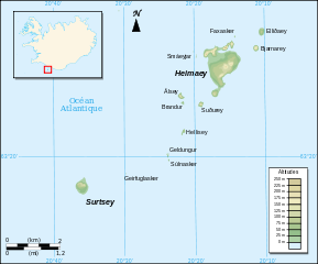
English: French Map of the Vestmannaeyjar.
Français : Carte en français des Îles Vestmann. |
| Dáta | |
| Foinse |
Travail personnel.
Sources :
Logiciels utilisés :
Autres données :
|
| Údar | Pinpin |

|
This SVG file contains embedded text that can be translated into your language, using any capable SVG editor, text editor or the SVG Translate tool. For more information see: About translating SVG files. |
This W3C-unspecified vector image was created with Inkscape .
Ceadúnú
Is mise sealbhóir cóipchirt an shaothair seo agus foilsím é faoi na ceadúnais seo a leanas:

|
Tugtar cead an doiciméad seo a chóipeáil, a dháileadh agus/nó a mhodhnú faoi théarmaí an Ceadúnas Doiciméadúcháin Saor ó GNU, Leagan 1.2 nó aon leagan níos déanaí a d’fhoilsigh an Fondúireacht Bogearraí Saor in Aisce; gan aon Rannóga Inmheánacha, gan aon Téacsanna Clúdaigh Tosaigh, agus gan aon Téacsanna Clúdaigh Cúil. Tá cóip den cheadúnas san áireamh sa chuid dar teideal Ceadúnas Doiciméadúcháin Saor ó GNU. |
This file is licensed under the Creative Commons Attribution-Share Alike 3.0 Unported, 2.5 Generic, 2.0 Generic and 1.0 Generic license.
- Is féidir:
- an saothar seo a roinnt – an saothar seo a chóipeáil, a dháil amach, agus a tharchur
- an saothar seo a athmheascadh – an saothar seo a oiriúnú
- Ach amháin má leantar na coinníollacha seo a leanas:
- sannadh – Ní mor creidiúint a thabhairt leis an saothar, faoi mar a shonraigh an údar nó tabharthóir an ceadúnais (ach ná húsáid modh a thugann le fios go thacaíonn sé/sí tú féin nó an úsáid a bhaineann tú as an saothar).
- comhroinn araon – Má athraíonn tú nó síneann tú amach an saothar seo, ní féidir é a dháileadh ach amhaín faoin gceadúnas céanna nó ceann cosúil leis an gceann seo.
Is féidir leat a roghnú an ceadúnas do rogha
Stair chomhaid
Cliceáil ar dáta/am chun an comhad a radharc mar a bhí sé ag an am sin.
| Dáta/Am | Mionsamhail | Toisí | Úsáideoir | Nóta tráchta | |
|---|---|---|---|---|---|
| faoi láthair | 00:31, 21 Nollaig 2010 | | 887 × 738 (323 KB) | Krun | Corrected text labels. |
| 17:33, 7 Márta 2008 |  | 887 × 738 (323 KB) | Pinpin | == Description == {{Information |Description= {{en| French Map of the Vestmannaeyjar.}} {{fr| Carte en français des Îles Vestmann.}} |Source=Travail personnel. {{clr}} Sources : * Fond de carte : [http://www |
Úsáid comhaid
Tá nasc chuig an gcomhad seo ar na leathanaigh seo a leanas:
Global file usage
The following other wikis use this file:
- Úsáid ar ar.wikipedia.org
- Úsáid ar arz.wikipedia.org
- Úsáid ar ca.wikipedia.org
- Úsáid ar es.wikipedia.org
- Úsáid ar fr.wikipedia.org
- Úsáid ar hr.wikipedia.org
- Úsáid ar hu.wikipedia.org
- Úsáid ar it.wikipedia.org
- Úsáid ar ro.wikipedia.org
- Úsáid ar ru.wikipedia.org
- Úsáid ar sh.wikipedia.org
- Úsáid ar uk.wikipedia.org
- Úsáid ar vi.wikipedia.org
- Úsáid ar www.wikidata.org